Quarry End Plenkertweg

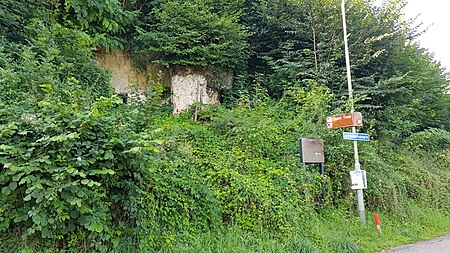
The Groeve Einde Plenkertweg is a marl quarry and geological monument in South Limburg, Netherlands, located in the municipality of Valkenburg aan de Geul. This underground limestone quarry is situated in the hamlet of Plenkert, west of Valkenburg, along Plenkertstraat. The quarry is located at the northwestern edge of the Polferbos forest on the northern edge of the Plateau of Margraten, transitioning into the Geuldal valley. Here, the plateau descends steeply several meters. Approximately 600 meters to the west lies the Viltergroeve quarry, about 30 meters to the west is the Pompstation Heytgracht, approximately 45 meters to the southwest is the Carolusgroeve, and around 250 meters to the east are the Roman Catacombs and the Heidegroeve.
Excerpt from the Wikipedia article Quarry End Plenkertweg (License: CC BY-SA 3.0, Authors, Images).Quarry End Plenkertweg
Plenkertstraat, Valkenburg aan de Geul
Geographical coordinates (GPS) Address Nearby Places Show on map
Geographical coordinates (GPS)
| Latitude | Longitude |
|---|---|
| N 50.865138888889 ° | E 5.8181472222222 ° |
Address
Groeve Eind van de Plenkertweg
Plenkertstraat
6301 KZ Valkenburg aan de Geul
Limburg, Netherlands
Open on Google Maps


