place

St. Peter's Catholic Church (Portland, Maine)

1929 establishments in Maine20th-century Roman Catholic church buildings in the United StatesCatholic churches in the United StatesChurches completed in 1929Churches in Portland, Maine
Churches in the Roman Catholic Diocese of PortlandMaine building and structure stubsNortheastern United States religious building and structure stubsRoman Catholic churches completed in 1929Roman Catholic churches in Maine
St. Peter Parish Church

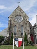
St. Peter's Catholic Church is a church located on Federal Street in downtown Portland, Maine, United States. Owned by the Roman Catholic Diocese of Portland, the church was built in 1929, and—being in the city's Italian neighborhood centered on India Street—today hosts Italian cultural events, including the annual Italian Bazaar on the feast day of Saint Rocco. It held its 97th bazaar in 2023. An engraving above the middle of its three doors reads "Tu Es Petrus" (You are Peter). As of 2024, its priest is the Very Revd. Seamus Griesbach.

Excerpt from the Wikipedia article St. Peter's Catholic Church (Portland, Maine) (License: CC BY-SA 3.0, Authors, Images).

St. Peter's Catholic Church (Portland, Maine)
Federal Street, Portland

Geographical coordinates (GPS) Address Phone number Nearby Places
placeShow on map

Wikipedia: St. Peter's Catholic Church (Portland, Maine)Continue reading on Wikipedia

Geographical coordinates (GPS)

Latitude Longitude
N 43.660837 ° E -70.251882 °
placeShow on map

Address

Saint Peters Catholic Church

Federal Street 72
04101 Portland
Maine, United States
mapOpen on Google Maps

Phone number

call+12077737746

St. Peter Parish Church
Share experience

Nearby Places

India Street
India Street

India Street is a downtown street and neighborhood in Portland, Maine, United States. Situated near the western foot of Munjoy Hill, it runs for around 0.28 miles (0.45 km), from Congress Street in the northwest to Commercial Street and Thames Street in the southeast. It was the city's first street, and the location of the first settlement of European immigrants to the city (then called Falmouth) in the 17th century. There are thirty handmade bricks in the sidewalk commemorating the neighborhood's notable events. In 1680, when Thomas Danforth was Deputy Governor of the Massachusetts Bay Colony, the street was known as Broad Street. After the incorporation of the Town of Falmouth in 1718, the street was known as High King Street. The neighborhood has been home to Europeans (1600s), African Americans (1700s), and Irish, Jews, Scots, Russians, Swiss and Portuguese (late 1800s). One of Portland's four stations for the Portland and Forest Avenue Railroad Company was located at the foot of India Street, at its intersection with Commercial Street and Thames Street. Known as the Grand Trunk Station, it was built in 1903, when it was one of the two stations in the city, the other being the Union Station, on Saint John Street, which was demolished in 1961. Grand Trunk Station was demolished five years later, having stood for sixty-three years; its clock tower had been taken down in 1948. Its office building remains intact, at the corner of India Street and Thames Street, in use as a Gorham Savings Bank as of 2024. Clay Cove, the home of early shipyards, stood at the foot of India Street in the 19th century. Atlantic Railroad Wharf formerly stood at the foot of India Street. It was demolished in the early 20th century, when Maine State Pier was constructed. After Portland's great fire of 1866, a fire house was built at 97 India Street. In the early 1950s, the newly created Slum Clearance and Redevelopment Authority highlighted Bayside and East Bayside as target neighborhoods due to its high number of immigrants and the decaying buildings caused by redlining. Residents of these neighborhoods resisted the discriminatory campaign. In 1958, the Authority demolished the Little Italy neighborhood, which spanned from the India Street neighborhood to the East Bayside neighborhood, razing 92 dwellings and 27 small businesses. Another 54 dwelling units were razed for the Bayside Park urban renewal project, an area that now includes Fox Field and Kennedy Park public housing. The first phase of the Kennedy Park was built in 1965. Several streets were truncated in an attempt to limit access to outside traffic. The razing of Franklin Street began in 1967; 130 homes and businesses were demolished and an unknown number of families relocated or were displaced. The India Street Historic District was designated by Portland City Council in 2015 after a unanimous (8–0) vote. As a result, maximum building heights of 50 feet (15 m) were introduced on India Street, as well as parts of Commercial Street, Middle Street and Congress Street. The following year, the Historic Preservation and Planning Board recommended that the boundaries of the India Street Historic District be expanded to include 96 and 100 Federal Street as contributing buildings. Portland City Council passed the motion in June. Etz Chaim Synagogue sits across from the head of India Street, at 267 Congress Street.

Maine Supreme Judicial Court

The Maine Supreme Judicial Court is the highest court in the state of Maine's judicial system. It is composed of seven justices, who are appointed by the Governor and confirmed by the Maine Senate. Between 1820 and 1839, justices served lifetime appointments with a mandatory retirement age of 70. Starting in 1839, justices have been appointed for seven-year terms, with no limit on the number of terms that they may serve nor a mandatory retirement age.Known as the Law Court when sitting as an appellate court, the Supreme Court's other functions include hearing appeals of sentences longer than one year of incarceration, overseeing admission to the bar and the conduct of its members, and promulgating rules for all the state's courts.The Maine Supreme Judicial Court is one of the few state supreme courts in the United States authorized to issue advisory opinions, which it does upon request by the governor or legislature, as set out in the Maine Constitution.It is also unusual for a state's highest appellate court in that its primary location is not that of the state's capital city, Augusta, partially because the Kennebec County Courthouse did not have a courtroom large enough for the Supreme Court's proceedings. The court did meet there from 1830 until 1970, when it permanently moved to the Cumberland County Courthouse. The renovation of the Kennebec County Courthouse in 2015, which included expansion of the bench in its largest courtroom to permit all seven justices to sit there at the same time, has allowed the court to meet there at least twice a year. It will also continue to meet in Portland, Bangor, and at high schools around the state. The new Judicial Center in Biddeford, scheduled to be completed in early 2023, will also contain a courtroom large enough to permit the court to sit there. The MSJC is also authorized to rule on the fitness of the Governor of Maine to serve in office, which it does upon the Maine Secretary of State certifying to the court that the governor is temporarily unable to carry out the duties of that office. The court must then hold a hearing and, if it agrees that the governor is unfit, declare the office of governor temporarily vacant and transfer its duties to the President of the Maine Senate, who would serve as acting governor. If the Secretary of State later certifies to the Supreme Court that the governor is fit to resume office, the court would then decide whether it agrees.

East Bayside
East Bayside

East Bayside is a neighborhood in Portland, Maine. It is bordered by Franklin Street on the west, Washington Avenue on the east, to the north by Marginal Way, and the south by Congress Street. It is bordered by the neighborhoods of Bayside, the Old Port and Munjoy Hill. It is often confused with the Bayside neighborhood, which is on the opposite side of Franklin Street. East Bayside was first developed a street network in the early 19th century. By the 1820s the area was Portland's second seaport via the Back Cove’s ship channel. Much of the debris from the great Portland fire of 1866 was deposited into Back Cove, significantly increasing the size of Bayside and East Bayside. Maps produced around 1900 show an extension of the shoreline out to Marginal Way and beyond. The shoreline would not change again until the construction of the Interstate in 1974. In the 19th century the Bayside and East Bayside neighborhoods were a mix of residential, commercial, and industrial uses. Manufacturing, including a foundry and a rope factory, was served, first by ship traffic on Back Cove and later, when the Cove channel was abandoned, by rail. The original rail line roughly forms the demarcation between the industrial zone, now located to the north of Fox Street, and the residential uses to the south. In the early 1950s the newly created Slum Clearance and Redevelopment Authority highlighted East Bayside as a target neighborhood. In 1958 the Authority demolished the Little Italy neighborhood, a portion of which was in what we now call East Bayside, razing 92 dwellings and 27 small businesses. Another 54 dwelling units were razed for the Bayside Park urban renewal project, an area that now includes Fox Field and Kennedy Park public housing. The first phase of the Kennedy Park was built in 1965. Several streets were truncated in an attempt to limit access to outside traffic. The razing of Franklin Street began in 1967; 100 structures were demolished and an unknown number of families relocated or were displaced. The neighborhood was cut off from Bayside and the Old Port when the four-lane, limited access Franklin Arterial was built to allow people who lived outside of Portland to enter and exit the city rapidly. Many existing streets, such as Oxford Street, were truncated by the creation of the road, creating a confusing street grid where roads have the same name but don't connect. The neighborhood has historically provided a home for recent immigrants with large population of Irish, Scandinavians, and Italians in the late 19th century. During the early 20th century over 250 Armenian families settled in the neighborhood. More recently East Bayside has become home to new immigrants including Cambodians, Vietnamese, and, most recently, Sudanese, Somalis, and Iraqis.The neighborhood is also prone to severe flooding events during King Tides, rainstorms, and during the spring snow melt. This is likely due to the fact that some of the area sits on artificial land. Climate change has proven to be a problem for Bayside, with some sources showing that Back Cove may expand back to its original pre-19-century levels by 2100, making most of Bayside uninhabitable once again.According to the 2010 census, Census Tract 5 is the most diverse section of Portland, Maine. It is 60% White, 21% Black, 6% Hispanic, 8% Asian, 1% Native American, and 4% Multiracial.In 2011, Mayo Street Arts, a community arts venue, opened on Mayo Street, adjacent to Kennedy Park in the previously unoccupied St. Angsar Church.