Johannisberg (Jena-Lobeda)

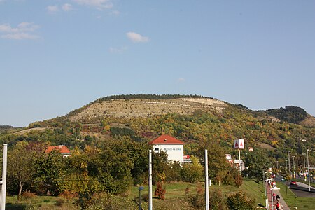
Johannisberg is a prominent ridge of the Wöllmisse, a Muschelkalk plateau east of Jena. The steeply sloping spur of land to the Saale Valley north of the district of Alt-Lobeda bears the remains of two important fortifications from the late Bronze Age and the early Middle Ages. Due to several archaeological excavations and finds recovered since the 1870s, they are among the few investigated fortifications from these periods in Thuringia. Of particular interest in archaeological and historical research is the early medieval castle. Due to its location directly on the eastern bank of the Saale, its dating and interpretation were and are strongly linked to considerations of the political-military eastern border of the Frankish empire. It is disputed whether it was a fortification of independent Slavic rulers or whether it was built under Frankish rule. According to a recent study, it may have been built in the second half of the 9th century in connection with the establishment of the limes sorabicus under Frankish influence.
Excerpt from the Wikipedia article Johannisberg (Jena-Lobeda) (License: CC BY-SA 3.0, Authors, Images).Johannisberg (Jena-Lobeda)
Burkholdsgrund, Jena Lobeda-Altstadt
Geographical coordinates (GPS) Address Nearby Places Show on map
Geographical coordinates (GPS)
| Latitude | Longitude |
|---|---|
| N 50.901388888889 ° | E 11.617777777778 ° |
Address
Burkholdsgrund
07747 Jena, Lobeda-Altstadt
Thuringia, Germany
Open on Google Maps


