Hoendiep
Canals in Groningen (province)Canals opened in 1616Interlanguage link template existing linkPages with Dutch IPA

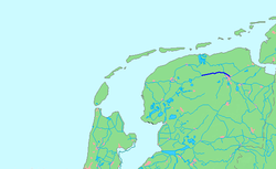
The Hoendiep (Dutch pronunciation: [ɦundip]; Gronings: Houndaip) is a canal in the Dutch province of Groningen, located between the city of Groningen and Zuidhorn. Before 1938, the current section of the Van Starkenborgh Canal from Zuidhorn to the Frisian border was also called Hoendiep. The road on the south side of the Van Starkenborgh Canal is still called Hoendiep. The current canal is 15 km long. The settlements of Groningen, Hoogkerk, De Poffert, Enumatil, Zuidhorn and Briltil are located on the Hoendiep.
Excerpt from the Wikipedia article Hoendiep (License: CC BY-SA 3.0, Authors, Images).Hoendiep
Hoendiep Westzijde, Westerkwartier
Geographical coordinates (GPS) Address Nearby Places Show on map
Geographical coordinates (GPS)
| Latitude | Longitude |
|---|---|
| N 53.231111 ° | E 6.397778 ° |
Address
Hoendiep Westzijde 24
9805 TC Westerkwartier
Groningen, Netherlands
Open on Google Maps


