place

Woofferton railway station

Disused railway stations in ShropshireFormer Shrewsbury and Hereford Railway stationsPages with no open date in Infobox stationRail junctions in EnglandRailway stations in Great Britain closed in 1961
Railway stations in Great Britain opened in 1853Use British English from December 2016West Midlands (region) railway station stubs
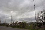
Woofferton station (disused) geograph.org.uk 316919

Woofferton railway station was a station and railway junction near Woofferton, Shropshire, England, where the Tenbury Railway joined the Shrewsbury and Hereford Railway (S&HR). The station opened on 6 December 1853 as part of the southern extension of the S&HR from Ludlow to Hereford. It became a junction station in August 1861 when the Tenbury Railway (operated by the S&HR) opened a 5-mile branch line. In August 1864 the GWR-operated Tenbury and Bewdley Railway opened, completing the 'Wyre Forest Line' to Bewdley. In 1889 a bay platform, known as the "Back Platform", was added to serve the Wyre Forest Line. This was accessed via two diamond crossings in the main lines and continued in use until being removed in 1957.The station closed on 31 July 1961, the same date as the closure of the former Tenbury Railway. The line through the station, the Welsh Marches Line, remains in use.

Excerpt from the Wikipedia article Woofferton railway station (License: CC BY-SA 3.0, Authors, Images).

Woofferton railway station
Station Road,

Geographical coordinates (GPS) Address Nearby Places
placeShow on map

Wikipedia: Woofferton railway stationContinue reading on Wikipedia

Geographical coordinates (GPS)

Latitude Longitude
N 52.3111 ° E -2.7136 °
placeShow on map

Address

Station Road

Station Road
SY8 4AW , Richard's Castle
England, United Kingdom
mapOpen on Google Maps

Woofferton station (disused) geograph.org.uk 316919
Share experience

Nearby Places

Brimfield, Herefordshire

Brimfield is a village and civil parish in north Herefordshire, England. The village lies on the A49 road at the border with Shropshire. To the south, near the hamlet of Ashton, excavations at the site of Ashton Castle have revealed traces of a large stone enclosure castle. Less than a mile to the north of this site are the earthwork remains of a medieval motte. The parish has a pub called The Roebuck Inn.Wyson is west of Brimfield and is part of its civil parish. To the north, in Shropshire, is Woofferton. The A49 ran through the village until a by-pass was built in 1982–83; the A49 now passes to the west, between Brimfield and Wyson. The village had a local store in its centre on Wyson Lane which served bread baked on site. The store was initially named A.A. Francis after Annie Amelia, later renamed R.R. Francis after her son Ronald Robert and then R. B. Francis after his son. The store closed and was sold to housing developers in 1996. Villagers later reinstated a local store annexed to The Roebuck which thrives today. The village also had a local Post Office which ran for over 100 years out of a building next door to The Roebuck which has been carefully restored as a residential premise called The Old Post Office. The Post Office facility now runs out of the Village Hall. These facilities and other various local landmarks such as The Foundry are depicted on a quilted display in the local church, St. Michael's. A penny sweet shop was run by a Mrs Humphreys opposite St. Michael's Gate. There is a vibrant local community offering many services in the Village Hall and support to inhabitants, including a long-running Grapevine newsletter.