place

Sörnäinen Harbour

1860s establishments in FinlandBuildings and structures in HelsinkiPorts and harbours of FinlandSörnäinenTransport infrastructure completed in 1863
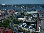
Sörnäinen Harbour in Helsinki, Finland, 1994

Sörnäinen Harbour (Finnish: Sörnäisten satama, Swedish: Sörnäs hamn) was for nearly one and a half centuries a major harbour and freight terminal in the Port of Helsinki, located in the Sörnäinen district on the eastern shore of the Helsinki city centre area.It was opened in 1863 to serve mainly the country's timber export trade, in 1889 an oil import terminal was added, and more recently containerised cargo and some passenger traffic. The harbour was finally closed down after 145 years of operation in November 2008, when the new Vuosaari Harbour was opened in the eastern suburb, and the facilities moved there. The only remaining functions relate to the adjacent Hanasaari Power Plant, which is itself being gradually decommissioned.The port facilities were connected to the rail network at Pasila station via a branch line called Sörnäinen harbour rail, which originally ran through Vallila, but which in 1965 was re-routed around the inner city area via Kumpula.Since its closure, the harbour area has been redeveloped for residential, retail and leisure use, as part of the Kalasatama development.The harbour was also commonly referred to as 'Sompasaari Harbour', after a small island which originally was located immediately to its south, but which the harbour development had subsumed under reclaimed land.

Excerpt from the Wikipedia article Sörnäinen Harbour (License: CC BY-SA 3.0, Authors, Images).

Sörnäinen Harbour
Nihdinranta, Helsinki Sompasaari (Central major district)

Geographical coordinates (GPS) Address Nearby Places
placeShow on map

Wikipedia: Sörnäinen HarbourContinue reading on Wikipedia

Geographical coordinates (GPS)

Latitude Longitude
N 60.1795 ° E 24.9752 °
placeShow on map

Address

Nihdinranta 6
00540 Helsinki, Sompasaari (Central major district)
Finland
mapOpen on Google Maps

Sörnäinen Harbour in Helsinki, Finland, 1994
Share experience

Nearby Places

Kalasatama
Kalasatama

Kalasatama (Swedish: Fiskehamnen; literally translated "fish port") is a neighbourhood in the city of Helsinki, Finland. The area is officially part of the Sörnäinen district; and like Sörnäinen, Kalasatama is located a little more than one kilometre north from the coastal centre of Helsinki, near the district of Hakaniemi, and the east side of Kalasatama borders the sea. Itäväylä, which leads in the direction of East Helsinki, runs next to Kalasatama. The Isoisänsilta pedestrian and cycling bridge, opened in 2016, connects Kalasatama to the nearby islands of Mustikkamaa, Korkeasaari and Kulosaari.Kalasatama is projected to become a rather densely built-up area - about 25,000 inhabitants expected to come there, about as many as in Kallio. In addition, jobs are planned for Kalasatama for about 10,000 people. A concentration of 23- to 35-storey skyscraper towers are coming to the Kalasatama center area around the Kalasatama metro station, which was completed in 2007. Two of the towers, called Majakka and Loisto, and the Redi shopping centre are already completed, while the third tower Lumo One is still under construction. Construction of the third tower, T7, began in the end of 2021.Attempts have been made to build a smart city from Kalasatama that focuses on smart sensors and robotics. Guide robots in the doctors' offices, robot buses and food delivery robots have already been on display in Kalasatama. Formerly there was a cargo harbour in Kalasatama (Sörnäinen harbour) but it was moved to Vuosaari in late 2008. After that the construction of the neighbourhood began.