place

Area code 724

Area codes in PennsylvaniaArea codes in the United StatesTelecommunications-related introductions in 1998
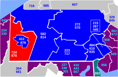
Area code 724
Area code 724

Area code 724 is a telephone area code in the North American Numbering Plan for the Commonwealth of Pennsylvania in western and southwestern Pennsylvania, including most of the suburbs of Pittsburgh. It was created in an area code split of area code 412 on February 1, 1998, which made the 412 numbering plan area (NPA) an enclave for the city, with 724 surrounding 412. In 2001, area codes 412 and 724 were overlaid with area code 878, so that the entire southwestern corner of Pennsylvania is served by area code 878.

Excerpt from the Wikipedia article Area code 724 (License: CC BY-SA 3.0, Authors, Images).

Area code 724
Gaskill Road, Jefferson Township

Geographical coordinates (GPS) Address Nearby Places
placeShow on map

Wikipedia: Area code 724Continue reading on Wikipedia

Geographical coordinates (GPS)

Latitude Longitude
N 40.052 ° E -79.826 °
placeShow on map

Address

Gaskill Road

Gaskill Road
15442 Jefferson Township
Pennsylvania, United States
mapOpen on Google Maps

Area code 724
Area code 724
Share experience

Nearby Places

Redstone Creek (Pennsylvania)

Redstone Creek is a historically important widemouthed canoe and river boat-navigable brook-sized tributary stream of the Monongahela River in Fayette County, Pennsylvania. The creek is 28.4 miles (45.7 km) long, running from headwaters on Chestnut Ridge north through the city of Uniontown and reaching the Monongahela at Brownsville. Located in a 1/4-mile-wide valley with low streambanks, the site was ideal for ship building in a region geologically most often characterized by steep-plunging relatively inaccessible banks — wide enough to launch and float several large boats, and indeed steamboats after 1811, and slow-moving enough to provide good docks and parking places while craft were outfitting. Brownsville, at the mouth of Redstone Creek, was an important center for boat-building, including the manufacture of paddlewheel steamboats that traveled as far as New Orleans, and, later, the upper navigable part of the Missouri. Flatboat construction is documented at the site from 1782, and the Braddock Expedition established a supply base (blockhouse) on the stream's south bank which the French destroyed after first taking Fort Necessity in 1754. The creek hosting this important activity played a critical role in the transshipment of goods and settlers in the Mississippi Basin, as it enabled the other industries in and around Brownsville to outfit and equip the settlers headed west. Nestled in the foothills on the west side of the mountains, Brownsville was a gateway funneling settlers to the Ohio Country, the lands of the Louisiana Territory, and did so until well after 1853, when railroads reached the Missouri River at Kanesville, Iowa (one Emigrant Trails destination of the town's flatboats), the far west and the Oregon Country —for the town astride the shortest, if not the easiest, land route across the great barrier to east-west traffic presented by the Allegheny Mountains.