place

Loddon Mallee

Loddon Mallee (region)Regions of Victoria (state)Use Australian English from May 2023
Australia Victoria Loddon Mallee region

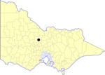
The Loddon Mallee is an economic rural region located in the north-western part of Victoria, Australia. Occupying more than a quarter of the state, it stretches from Greater Melbourne to the northernmost point of Victoria, sharing a border with South Australia and New South Wales, and has one of the most consistently warm climates in Victoria. It has two major regional cities Bendigo and Mildura and also contains the major settlements of Castlemaine, Echuca, Gisborne, Kerang, Kyneton, Maryborough, Swan Hill, Wedderburn and Wycheproof. Comprising an area in excess of 58,000 square kilometres (22,000 sq mi) this is the largest region in Victoria hosting a population of over 348,000 people. The Loddon Malle region includes the Shire of Buloke, Shire of Campaspe, Shire of Central Goldfields, Shire of Gannawarra, City of Greater Bendigo, Shire of Loddon, Shire of Macedon Ranges, Rural City of Mildura, Shire of Mount Alexander and Rural City of Swan Hill local government areas. The Loddon Mallee region is located along two major transport corridors, the Calder Highway corridor linking Melbourne to Bendigo and Mildura and the interstate Sturt Highway corridor linking Sydney to Mildura and Adelaide. The region comprises two distinct and inter-connected sub-regions or districts: Loddon Campaspe and Mallee.

Excerpt from the Wikipedia article Loddon Mallee (License: CC BY-SA 3.0, Authors, Images).

Loddon Mallee
Bannerman Street, Bendigo

Geographical coordinates (GPS) Address Nearby Places
placeShow on map

Wikipedia: Loddon MalleeContinue reading on Wikipedia

Geographical coordinates (GPS)

Latitude Longitude
N -36.75 ° E 144.26666666667 °
placeShow on map

Address

Bannerman Street

Bannerman Street
3550 Bendigo (Bendigo)
Victoria, Australia
mapOpen on Google Maps

Australia Victoria Loddon Mallee region
Share experience

Nearby Places

Bendigo
Bendigo

Bendigo ( BEN-dig-oh) is a city in Victoria, Australia, located in the Bendigo Valley near the geographical centre of the state and approximately 150 kilometres (93 mi) north-west of Melbourne, the state capital. As of 2022, Bendigo has a population of 103,818 making it Australia's 19th-largest city by population. Bendigo is the fourth-largest inland city in Australia and the fourth-most populous city in Victoria. Bendigo is administered by the City of Greater Bendigo. The council area encompasses roughly 3,000 square kilometres, the city is surrounded by smaller towns and cities like Castlemaine and Heathcote. The traditional owners of the area are the Dja Dja Wurrung (Djaara) people. The discovery of gold on Bendigo Creek in 1851 transformed the area from a sheep station into one of colonial Australia's largest boomtowns. News of the finds intensified the Victorian gold rush, bringing an influx of migrants from around the world, particularly Europe and China. Bendigo became eastern Australia's largest 19th-century gold-mining economy and the wealth generated during this period is reflected today in the city's Victorian architectural heritage. From 1853 until 1891, Bendigo was officially named Sandhurst. Bendigo's boom period lasted until the early 20th century and after a temporary decline in population and employment, renewed growth occurred from the 1930s as the city consolidated as a manufacturing and regional service centre. Although gold mining continues, recent population growth has been most heavily concentrated in suburban areas. With the completion of the Calder Freeway linking Melbourne and Bendigo in 2009, and the region's proximity to Melbourne, Bendigo has become one of the fastest-growing regional centres in Victoria.