place

Cantlop Bridge

Bridges by Thomas TelfordBridges in ShropshireEnglish Heritage sites in ShropshireGrade II* listed buildings in ShropshireStructural engineering
Use British English from March 2017
Cantlop Bridge 2016
Cantlop Bridge 2016

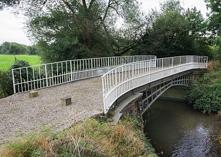
Cantlop Bridge is a single span cast-iron road bridge over the Cound Brook, located to the north of Cantlop in the parish of Berrington, Shropshire. It was constructed in 1818 to a design possibly by Thomas Telford, having at least been approved by him, and replaced an unsuccessful cast iron coach bridge constructed in 1812. The design of the bridge was innovative for the period, using a light-weight design of cast-iron lattice ribs to support the road deck in a single span, and appears to be a scaled-down version of a Thomas Telford bridge at Meole Brace, Shropshire. The bridge is the only surviving Telford-approved cast-iron bridge in Shropshire, and is a Grade II* listed building and scheduled monument. It originally carried the turnpike road from Shrewsbury to Acton Burnell.

Excerpt from the Wikipedia article Cantlop Bridge (License: CC BY-SA 3.0, Authors, Images).

Cantlop Bridge
Cantlop Bridge,

Geographical coordinates (GPS) Address External links Nearby Places
placeShow on map

Wikipedia: Cantlop BridgeContinue reading on Wikipedia

Geographical coordinates (GPS)

Latitude Longitude
N 52.6518 ° E -2.7148 °
placeShow on map

Address

Cantlop Bridge

Cantlop Bridge
SY5 7DD
England, United Kingdom
mapOpen on Google Maps

linkWikiData (Q5033841)
linkOpenStreetMap (239139875)

Cantlop Bridge 2016
Cantlop Bridge 2016
Share experience

Nearby Places

Shropshire
Shropshire

Shropshire (; historically Salop and abbreviated Shrops) is a ceremonial county in the West Midlands of England, on the Welsh border. It is bordered by Wrexham County Borough and Cheshire to the north, Staffordshire to the east, Worcestershire to the south-east, Herefordshire to the south and Powys to the west. The largest settlement is Telford, and Shrewsbury is the county town. The county has an area of 3,487 square kilometres (1,346 sq mi) and a population of 498,073. Telford (155,570), in the east of the county, and Shrewsbury (76,782), in the centre, are the only large towns. Shropshire is otherwise rural, containing market towns such as Oswestry (15,613), Bridgnorth (12,212) and Newport (11,387). The county contains two districts, Shropshire and Telford and Wrekin, which are both unitary areas. Shropshire is generally flat in the north and hilly in the south, where the Shropshire Hills AONB covers about a quarter of the county, including The Wrekin, Clee Hills, Stiperstones, Long Mynd and Wenlock Edge. Part of the Fenn's, Whixall and Bettisfield Mosses National Nature Reserve, which extends into Wales, occupies the low-lying north west of the county. The River Severn, Great Britain's longest river, runs through the county in a wide, flat valley before exiting into Worcestershire south of Bridgnorth. The village of Edgmond, near Newport, is the location of the lowest recorded temperature (in terms of weather) in England and Wales.There is evidence of Neolithic and Bronze Age human occupation in Shropshire, including the Shropshire bulla pendant. The hillfort at Old Oswestry dates from the Iron Age, and the remains of the city of Viroconium Cornoviorum date from the Roman period. During the Anglo-Saxon era the area was part of Mercia. During the High Middle Ages the county was part of the Welsh Marches, the border region between Wales and England; from 1472 to 1689 Ludlow was the seat of the Council of Wales and the Marches, which administered justice in Wales and Herefordshire, Shropshire, Worcestershire and Gloucestershire. During the English Civil War Shropshire was Royalist, and Charles II fled through the county—famously hiding in an oak tree—after his final defeat at the Battle of Worcester. The area around Coalbrookdale is regarded as one of the birthplaces of the Industrial Revolution and has been designated a UNESCO World Heritage Site.