place

Nooksack River

Geography of Bellingham, WashingtonLynden, WashingtonNooksackRivers of Washington (state)Rivers of Whatcom County, Washington
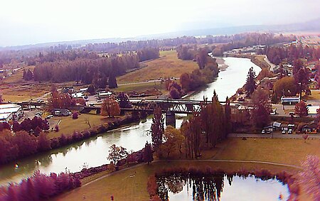
Noonsack river aerial

The Nooksack River is a river in western Whatcom County of the northwestern U.S. state of Washington, draining extensive valley systems within the North Cascades around Mount Shuksan, Mount Baker and the Twin Sisters, and a portion of Fraser Lowland south of the Canada–United States border. The river proper begins with the merging of three main tributaries, namely the North Fork, Middle Fork and South Fork, near Deming. All three forks originate in the Mount Baker Wilderness, and the North Fork, the longest of the three, is sometimes considered the main river. The Nooksack is approximately 75 miles (121 km) in total length measuring from the North Fork headwaters. The lower Nooksack flows as a northerly loop through the fertile southern Fraser Lowland agricultural area before emptying into Bellingham Bay and, via the Strait of Juan de Fuca and the Strait of Georgia, communicating with the Pacific Ocean.

Excerpt from the Wikipedia article Nooksack River (License: CC BY-SA 3.0, Authors, Images).

Nooksack River
Lummi Shore Road,

Geographical coordinates (GPS) Address Nearby Places
placeShow on map

Wikipedia: Nooksack RiverContinue reading on Wikipedia

Geographical coordinates (GPS)

Latitude Longitude
N 48.774722222222 ° E -122.59916666667 °
placeShow on map

Address

Lummi Shore Road

Lummi Shore Road
98262
Washington, United States
mapOpen on Google Maps

Noonsack river aerial
Share experience

Nearby Places

Fort Bellingham
Fort Bellingham

Fort Bellingham (1856–1860) was a U.S. Army fort built to prevent attacks by Indians from Canada and from Russian territory, on the bayside villages of Fairhaven, Sehome and Whatcom. The site for the new fort was on a prairie that overlooked Bellingham Bay. It was the only open space on the bay and had a spring. A settler, Maria Roberts, had to be evicted to build the fort, but she and her husband were later allowed to build a cabin on the beach. The fort was built by U.S. Army Captain George E. Pickett and Company D of the 9th U.S. Infantry Regiment sent from Fort Steilacoom. Construction started August 26, 1856. The fort was an 80-yard square stockade with three gates. Two blockhouses of two stories lay at opposite corners, flanking the stockade walls loopholed for rifles and mountain howitzers. Within the stockade were wood-framed one-story buildings including the barracks, storehouses, officers quarters, mess hall, kitchen, and bakery. In July 1859, the Pig War broke out on San Juan Island when an American settler, Lyman Cutlar, shot a Hudson’s Bay Company pig. Brigadier General William S. Harney, Department of Oregon commander, learned that British authorities in Victoria had threatened to arrest Cutlar and dispatched Pickett’s company from Fort Bellingham to the island to protect American interests. In response, the British sent warships and a detachment of marines. While the opposing forces that summer were facing off at San Juan Island, Pickett’s men returned and dismantled pieces of Fort Bellingham including one of the blockhouses and reassembled them on the island’s southern shore creating "Camp Pickett" later called "Post of San Juan". What remained of Fort Bellingham was removed by units later occupying the San Juan Island post to improve or repair buildings in their camp. In 1861, the Washington Territorial Legislature asked the federal government to post at least one company at the fort to keep it open, but that never occurred. The fort officially closed in 1863. By then, only the blockhouse on the northwest corner and a few other structures remained. In 1868, the Army returned 320 acres (1.3 km2) to Mrs. Roberts, who lived there for many years thereafter and farmed the land. In 1897, the blockhouse burned down. Few traces of the fort remain today. The officer's quarters (that housed Capt. George E. Pickett and his Indian wife) is preserved at 910 Bancroft Street in the Lettered Streets neighborhood of Bellingham, Washington. The site of the fort is several miles north along the shore of the bay, closer to the mouth of the Nooksack River.

Lummi River

The Lummi River is the current name for a river channel that was, prior to the beginning of the 20th century, the main outflow channel for the Nooksack River. It then emptied into Lummi Bay rather than Bellingham Bay, as the current channel of the Nooksack River does. At the time, the channel that now serves as the main channel of the Nooksack River was restricted by a massive, mile-long, log jam. This was the result of the timber industry floating logs downriver to ports for processing and shipping. In the late 19th century, with an interest in creating a navigable waterway that would empty into Bellingham Bay and be usable beyond Ferndale, the city of Bellingham commissioned removal of the log jam. Once the log jam was removed, the river's flow shifted into the southern channel. The headwaters of the Lummi River were restricted by a dam, which was later damaged. It was replaced by a dam and spillway system, which was also later damaged. Today the Lummi River is fed by water from the Nooksack River only during times of high water, by a culvert that passes through the levee. The Lummi River today is characterized by a narrow channel. As its main purpose is as a high water overflow, it has been artificially channelized and diked to prevent flooding of surrounding agricultural fields. It has a low flow as a result of its short course across glacially ploughed flatlands. The considerable reduction in the flow of the river has allowed erosive processes to strongly affect the Lummi River Delta. It was formerly of considerable size, and might have been comparable to the modern Nooksack River Delta in Bellingham Bay. The channelization and diking of the river resulted in the production of significant new areas of rich farmland, but it has cost the elimination of an equal or greater acreage of coastal wetlands and damage to important salmon habitats. Because of the importance of salmon to indigenous tribes, commercial and sports fishermen, state and local governments are evaluating proposals to investigate restoration of these habitats.