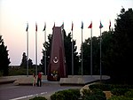
Upland Cemetery

The Upland Cemetery. (Azerbaijani: Dağüstü qəbiristanlığı) or the Pir-Vanzari Cemetery was a multi-confessional cemetery located in Baku until the first half of the 1930s. The cemetery was placed on the top of the Baku hill, known as Pirvanzari, situated to the southwest of the Chemberekend village, a suburb of Baku. On the Baku urban plan of 1899, compiled by the city engineer the Colonel Nikolai von der Nonne, it can be seen that the cemetery during this period consisted of a number of sections: Muslim, Orthodox, Catholic, Lutheran, Jewish and Molokan. Also, on the territory of the cemetery were located several chapels.In the first half of the 1930s, the cemetery was demolished, and a park named after Sergei Kirov was laid out on this site. In 1990, the bodies of the Black January tragedy victims, and subsequently those who died during the Karabakh war, were buried in the former Muslim part of the cemetery. Today this area is known as the Martyrs' Alley.
Excerpt from the Wikipedia article Upland Cemetery (License: CC BY-SA 3.0, Authors, Images).Upland Cemetery
Saraykina küç., Baku
Geographical coordinates (GPS) Address Nearby Places Show on map
Geographical coordinates (GPS)
| Latitude | Longitude |
|---|---|
| N 40.357222222222 ° | E 49.829166666667 ° |
Address
Türk Əsgəri Abidəsi
Saraykina küç.
1066 Baku
Baku Ekonomic Zone, Azerbaijan
Open on Google Maps


