Nestucca River

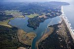
The Nestucca River flows for about 57 miles (92 km) through forests near the Pacific coast of northwest Oregon in the United States. It drains a timber-producing area of the Northern Oregon Coast Range west of Portland. Rising in the mountains of western Yamhill County, it is impounded near its headwaters to create McGuire Reservoir, the primary water source for the city of McMinnville. The river flows generally west through Bureau of Land Management (BLM) land and the Siuslaw National Forest, past Beaver, then southwest past Hebo and Cloverdale. It enters Nestucca Bay, on the Pacific Ocean, from the north at Pacific City. The Little Nestucca River does not join the Nestucca but enters Nestucca Bay from the south.
Excerpt from the Wikipedia article Nestucca River (License: CC BY-SA 3.0, Authors, Images).Nestucca River
River Trail,
Geographical coordinates (GPS) Address Nearby Places Show on map
 Continue reading on Wikipedia
 Geographical coordinates (GPS)
| Latitude | Longitude |
|---|---|
| N 45.184166666667 ° | E -123.95722222222 ° |
Address
River Trail
River Trail
97135
Oregon, United States
Open on Google Maps