place

Grande Inscription d'Angkor

1701 poems18th-century inscriptions18th century in CambodiaAngkor WatCambodian literature
Historiography of CambodiaNational symbols of CambodiaPoetrySteles
Grande inscription d'Angkor

The Grande Inscription d’Angkor, referenced as K. 301 or Inscription Modern Angkor Wat (IMA) #38, is the longest Khmer inscription at Angkor Wat. Dated to 1701, it is located on the east wall between the bas-relief galleries and facing the Chey Non stupa in the courtyard outside. It is considered to be the only dated Middle Khmer metrical poem.

Excerpt from the Wikipedia article Grande Inscription d'Angkor (License: CC BY-SA 3.0, Authors, Images).

Grande Inscription d'Angkor
Temporary access, Siem Reap

Geographical coordinates (GPS) Address Nearby Places
placeShow on map

Wikipedia: Grande Inscription d'AngkorContinue reading on Wikipedia

Geographical coordinates (GPS)

Latitude Longitude
N 13.412681951379 ° E 103.8681891518 °
placeShow on map

Address

អង្គរវត្ត

Temporary access
171253 Siem Reap
Siem Reap, Cambodia
mapOpen on Google Maps

Grande inscription d'Angkor
Share experience

Nearby Places

Angkor Wat
Angkor Wat

Angkor Wat (; Khmer: អង្គរវត្ត, "City/Capital of Temples") is a Hindu-Buddhist temple complex in Cambodia, located on a site measuring 162.6 hectares (1,626,000 m2; 402 acres). It resides within the ancient Khmer capital city of Angkor. The Guinness World Records considers it as the largest religious structure in the world. Originally constructed as a Hindu temple dedicated to the god Vishnu for the Khmer Empire by King Suryavarman II during the 12th century, it was gradually transformed into a Buddhist temple towards the end of the century; as such, it is also described as a "Hindu-Buddhist" temple.Angkor Wat was built at the behest of the Khmer King Suryavarman II in the early 12th century in Yaśodharapura (Khmer: យសោធរបុរៈ, present-day Angkor), the capital of the Khmer Empire, as his state temple and eventual mausoleum. Angkor Wat combines two basic plans of Khmer temple architecture: the temple-mountain and the later galleried temple. It is designed to represent Mount Meru, home of the devas in Hindu mythology: within a moat more than 5 kilometres (3 mi) long and an outer wall 3.6 kilometres (2.2 mi) long are three rectangular galleries, each raised above the next. At the centre of the temple stands a quincunx of towers. Unlike most Angkorian temples, Angkor Wat is oriented to the west; scholars are divided as to the significance of this. The temple is admired for the grandeur and harmony of the architecture, its extensive bas-reliefs, and for the numerous devatas adorning its walls. The modern name Angkor Wat, alternatively Nokor Wat, means "Temple City" or "City of Temples" in Khmer. Angkor (អង្គរ ângkôr), meaning "city" or "capital city", is a vernacular form of the word nokor (នគរ nôkôr), which comes from the Sanskrit/Pali word nagara (Devanāgarī: नगर). Wat (វត្ត vôtt) is the word for "temple grounds", also derived from Sanskrit/Pali vāṭa (Devanāgarī: वाट), meaning "enclosure".The original name of the temple was Vrah Viṣṇuloka or Parama Viṣṇuloka meaning "the sacred dwelling of Vishnu".

Angkor
Angkor

Angkor (Khmer: អង្គរ [ʔɑŋkɔː], lit. 'Capital city'), also known as Yasodharapura (Khmer: យសោធរបុរៈ; Sanskrit: यशोधरपुर), was the capital city of the Khmer Empire. The city and empire flourished from approximately the 9th to the 15th centuries. The city houses the Angkor Wat, one of Cambodia's most popular tourist attractions. The name Angkor is derived from nokor (នគរ), a Khmer word meaning "kingdom" which in turn derived from Sanskrit nagara (नगर), meaning "city". The Angkorian period began in AD 802, when the Khmer Hindu monarch Jayavarman II declared himself a "universal monarch" and "god-king", and lasted until the late 14th century, first falling under Ayutthayan suzerainty in 1351. A Khmer rebellion against Siamese authority resulted in the 1431 sacking of Angkor by Ayutthaya, causing its population to migrate south to Longvek. The alternate name, Yasodharapura, was derived from the name of the foster mother of Lord Krishna in Hinduism. Hinduism was the largest religion in the ancient Khmer Empire, and many temples were constructed by Khmer kings dedicated to Hindu deities, including Angkor Wat. 
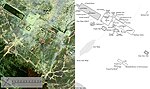
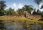
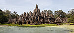
The ruins of Angkor are located amid forests and farmland north of the Great Lake (Tonlé Sap) and south of the Kulen Hills, near modern-day Siem Reap city (13°24′N, 103°51′E), in Siem Reap Province. The temples of the Angkor area number over one thousand, ranging in scale from nondescript piles of brick rubble scattered through rice fields to the Angkor Wat, said to be the world's largest single religious monument. Many of the temples at Angkor have been restored, and together, they comprise the most significant site of Khmer architecture. Visitors approach two million annually, and the entire expanse, including Angkor Wat and Angkor Thom is collectively protected as a UNESCO World Heritage Site. The popularity of the site among tourists presents multiple challenges to the preservation of the ruins. In 2007, an international team of researchers using satellite photographs and other modern techniques concluded that Angkor had been the largest pre-industrial city in the world by surface area, with an elaborate infrastructure system connecting an urban sprawl of at least 1,000 square kilometres (390 sq mi) to the well-known temples at its core. Angkor is considered to be a "hydraulic city" because it had a complicated water management network, which was used for systematically stabilizing, storing, and dispersing water throughout the area. This network is believed to have been used for irrigation in order to offset the unpredictable monsoon season and to also support the increasing population. Although the size of its population remains a topic of research and debate, newly identified agricultural systems in the Angkor area may have supported between 750,000 and one million people.