place

Roman Catholic Archdiocese of Tours

Archbishops of ToursBishops of ToursOrganizations based in Tours, FranceRoman Catholic dioceses in France
Cathédrale Saint Gatien de Tours

The Archdiocese of Tours (Latin: Archidioecesis Turonensis; French: Archidiocèse de Tours) is a Latin Church archdiocese of the Catholic Church in France. The archdiocese has roots that go back to the 3rd century, while the formal erection of the diocese dates from the 5th century. The ecclesiastical province of Tours corresponds with the late Roman province of Tertia Lugdunensis. During Breton independence the see of Dol briefly exercised metropolitical functions (mainly tenth century). In 1859 the Breton dioceses except that of Nantes were constituted into a province of Rennes. Tours kept its historic suffragans of Le Mans, Angers together with Nantes and a newly constituted Diocese of Laval. In 2002 Tours lost all connection with its historic province, all its previous suffragans depending henceforth on an expanded province of Rennes (corresponding to the Brittany and Pays de la Loire administrative regions). Tours since 2002 has become the ecclesiastical metropolis of the Centre administrative region.

Excerpt from the Wikipedia article Roman Catholic Archdiocese of Tours (License: CC BY-SA 3.0, Authors, Images).

Roman Catholic Archdiocese of Tours
Quai Paul Bert, Tours Paul Bert

Geographical coordinates (GPS) Address Nearby Places
placeShow on map

Wikipedia: Roman Catholic Archdiocese of ToursContinue reading on Wikipedia

Geographical coordinates (GPS)

Latitude Longitude
N 47.4 ° E 0.69 °
placeShow on map

Address

Quai Paul Bert
37000 Tours, Paul Bert
Centre-Val de Loire, France
mapOpen on Google Maps

Cathédrale Saint Gatien de Tours
Share experience

Nearby Places

Tours
Tours

Tours ( TOOR, French: [tuʁ] ) is one of the largest cities in the region of Centre-Val de Loire, France. It is the prefecture of the department of Indre-et-Loire. The commune of Tours had 136,463 inhabitants as of 2018 while the population of the whole metropolitan area was 516,973.Tours sits on the lower reaches of the Loire, between Orléans and the Atlantic coast. Formerly named Caesarodunum by its founder, Roman Emperor Augustus, it possesses one of the largest amphitheaters of the Roman Empire, the Tours Amphitheatre. Known for the Battle of Tours in 732 AD, it is a National Sanctuary with connections to the Merovingians and the Carolingians, with the Capetians making the kingdom's currency the Livre tournois. Saint Martin and Gregory of Tours were from Tours. Tours was once part of Touraine, a former province of France. Tours was the first city of the silk industry. It was wanted by Louis XI, royal capital under the Valois Kings with its Loire castles and city of art with the School of Tours. The prefecture was partially destroyed during the French Wars of Religion in the late 16th century and again during the Second World War in June 1940. The White and Blue city keeps a historical center registered in the UNESCO, and is home to the Vieux-Tours, a patrimonial site. The garden city has a green heritage and an urban landscape strongly influenced by its natural space. The historic city that is nicknamed "Le Petit Paris" and its region by its history and culture has always been a land of birth or host to many personalities, international sporting events, and is a university city with more than 30,000 students in 2019. Tours is a popular culinary city with specialties such as: rillettes, rillons, Touraine vineyards, AOC Sainte-Maure-de-Touraine cheeses and nougats. The city is also the end-point of the annual Paris–Tours cycle race.

Battle of Tours
Battle of Tours

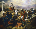
The Battle of Tours, also called the Battle of Poitiers and the Battle of the Highway of the Martyrs (Arabic: معركة بلاط الشهداء, romanized: Maʿrakat Balāṭ ash-Shuhadā'), was fought on 10 October 732, and was an important battle during the Umayyad invasion of Gaul. It resulted in the victory for the Frankish and Aquitanian forces, led by Charles Martel, over the invading Muslim forces of the Umayyad Caliphate, led by Abd al-Rahman al-Ghafiqi, governor of al-Andalus. Several historians, such as Edward Gibbon, have credited the Christian victory in the battle as an important factor in curtailing the Islamization of Western Europe.Details of the battle, including the number of combatants and its exact location, are unclear from the surviving sources. Most sources agree that the Umayyads had a larger force and suffered heavier casualties. Notably, the Frankish troops apparently fought without heavy cavalry. The battlefield was located somewhere between the cities of Poitiers and Tours, in northern Aquitaine in western France, near the border of the Frankish realm and the then-independent Duchy of Aquitaine under Odo the Great. Al-Ghafiqi was killed in combat, and the Umayyad army withdrew after the battle. The battle helped lay the foundations of the Carolingian Empire and Frankish domination of western Europe for the next century. Most historians agree that "the establishment of Frankish power in western Europe shaped that continent's destiny and the Battle of Tours confirmed that power."

Tours Amphitheatre
Tours Amphitheatre

The Tours amphitheater (also known as the Caesarodunum amphitheater) is a Roman amphitheatre located in the historic city center of Tours, France, immediately behind the well known Tours cathedral. It was built in the 1st century when the city was called Caesarodunum. It was built atop a small hill on the outskirts of the ancient urban area, making it safe from floods, convenient for crowds and visitors, and demonstrating the power of the city from a distance. The structure was an enormous, elliptical structure approximately 122 meters by 94 meters. According to its design it is classified as a "primitive" amphitheatre. Unlike the famous Colosseum that was made mostly of masonry and built above-ground, the Tours amphitheatre was made mostly of earth and created by moving soil and rock into a bowl shape. Spectators likely sat directly on the grassy slopes, while the masonry was primarily used for the vomitoria and retaining walls. When it was expanded in the 2nd century (to 156 m X 134 m), it became one of the largest structures (among the top ten) in the Roman Empire. It is not clear why the amphitheater was expanded given the population and slow growth of the city at the time. About a century later, this expanded amphitheatre was transformed into a fortress, with an addition of a rampart style wall, typical during the decline of Roman Empire. It gradually fell into ruin during the Middle Ages and canonical houses were built upon it and gradually concealed it. The vomitoria were at some point transformed into cellars. The amphitheater was then completely forgotten until the 19th century, when it was rediscovered (1855). Evidence such as the layout of the streets and radiating lots of the district drew attention to its existence. Surveys and terrain analyses in the 1960s gathered further data on the cellars of the houses which were previously built on the amphitheater walls. Over the past decade, more in-depth studies of the topography and architecture have taken place and are changing the theories and opinions surrounding this monument. The remains of the amphitheater are not protected as historic sites directly; however, some of the houses built upon it are registered as historical monuments. The ruins of the amphitheater are significant as they are among the oldest known ruins in the city and offer clues about the early history and development of the area.