place

Geiger Heights, Washington

Eastern Washington geography stubsUnincorporated communities in Spokane County, WashingtonUnincorporated communities in Washington (state)Use mdy dates from November 2021
Geiger Heights Homes

Geiger Heights is an unincorporated community in Spokane County, Washington, United States. It takes its name from nearby Spokane International Airport, formerly named Geiger Field, located a few miles to the northwest.

Excerpt from the Wikipedia article Geiger Heights, Washington (License: CC BY-SA 3.0, Authors, Images).

Geiger Heights, Washington
West John Gay Drive,

Geographical coordinates (GPS) Address Nearby Places
placeShow on map

Wikipedia: Geiger Heights, WashingtonContinue reading on Wikipedia

Geographical coordinates (GPS)

Latitude Longitude
N 47.592777777778 ° E -117.49083333333 °
placeShow on map

Address

West John Gay Drive 5495
99224
Washington, United States
mapOpen on Google Maps

Geiger Heights Homes
Share experience

Nearby Places

High Bridge (Latah Creek)

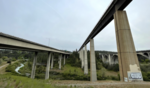
High Bridge, a railroad bridge over Latah Creek in Spokane, Washington, was constructed in 1972 by the Burlington Northern Railroad, following that railroad's creation in 1970 through the merger of the Chicago, Burlington & Quincy, Great Northern, Northern Pacific, and Spokane, Portland & Seattle railways. The bridge links the former Northern Pacific mainline with the former Great Northern and Spokane, Portland & Seattle lines to the west. The Latah Creek railroad bridge and two bridges carrying Interstate 90 and Sunset Highway cross High Bridge Park and the Latah/Hangman neighborhood of Spokane from Downtown Spokane on the east into the West Hills and Grandview/Thorpe neighborhoods to the west. The bridge is 3,950 feet (1,200 m) long, and its piers reach up to 175 feet (53 m) from the Latah Creek canyon floor. It is constructed of six weathering high-strength steel 160-foot-long (49 m) box girders spans bridging the canyon itself, with adjacent spans from 80 to 100 feet (24 to 30 m), supported by concrete piers. A ballasted concrete deck slab supports the railroad track. The western end of the bridge splits to form a wye.Although not the architect on record, Warren C. Heylman is said to have been the architect behind the design of the bridge, writing Burlington Northern with his "free and unsolicited" advice after he saw the initial plans for the bridge over Hangman valley that was to replace the downtown rail line they had removed in preparation for Expo '74, saying he had to act after seeing their heavily trellised design that would have obscured the historic arches of the Latah Creek Bridge. Heylman never heard back from the railroad company, but says that bridge that was built, a much simpler design with long concrete legs that complemented the nearby I-90 bridge was his. According to the opinion of Washington State University architecture and engineering professor, David Scott, the bridge is arguably Heylman's best work, saying it is "one of the finest examples of what a railroad bridge can look like or be."

Latah Creek
Latah Creek

Latah Creek ( LAY-tə), also known as Hangman Creek, is a large stream in eastern Washington and north central Idaho in the United States. The creek flows northwest from the Rocky Mountains to Spokane, where it empties into the Spokane River. It drains 673 square miles (1,740 km2) in parts of Benewah and Kootenai counties in Idaho, Spokane County and a small portion of Whitman County in Washington, where over 64 percent of its watershed resides. Some major tributaries of the approximately 60-mile (97 km) creek include Little Latah Creek (also known as Little Hangman Creek) and Rock Creek. The average flow of the creek can range from 20 cubic feet per second (0.57 m3/s) to 20,000 cubic feet per second (570 m3/s). Latah Creek receives its name from a Nez Perce word likely meaning "fish". In 1854, the creek received another name, Hangman Creek, from a war between the Palouse Indians and white soldiers, which resulted in several Palouse being hanged alongside the creek. The Latah Creek watershed is dominated by agriculture, which has released large amounts of sediment from the surrounding Palouse soils into the watershed on an annual basis. This has caused the ruin of natural fish populations, riparian zones, and natural flow patterns. The creek has been channelized in some places, and meanders, islands and natural channel formations have been destroyed. In response to these damaging factors, the water quality overall in the Latah Creek basin is quite low, and "Washington State water quality standards for temperature, dissolved oxygen, pH, and fecal coliforms are routinely violated." The remaining third of the land in the watershed is mostly forest.