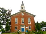
Clintondale, Pennsylvania
Clintondale is an unincorporated community and census-designated place (CDP) in Clinton County, Pennsylvania, United States. It was first listed as a CDP prior to the 2020 census.The CDP is in southern Clinton County, in the west-central part of Porter Township. It is bordered to the southwest by Fishing Creek, across which is the CDP of Lamar. Fishing Creek is a northeast-flowing tributary of Bald Eagle Creek, part of the West Branch Susquehanna River watershed. Pennsylvania Route 64 forms the northwest boundary of Clintondale; it leads northeast 6 miles (10 km) to Mill Hall and southwest 26 miles (42 km) to State College. Interstate 80 passes just north of Clintondale, with access from Exit 173 (PA 64). I-80 leads east 38 miles (61 km) to the Milton area and west 56 miles (90 km) to Clearfield. Clintondale is in the northeast part of the Nittany Valley, with 2,100-foot (640 m) Big Mountain rising 1 mile (1.6 km) to the south and 1,680-foot (510 m) Bald Eagle Mountain 3 miles (5 km) to the north.
Excerpt from the Wikipedia article Clintondale, Pennsylvania (License: CC BY-SA 3.0, Authors).Clintondale, Pennsylvania
Fishing Creek Road, Porter Township
Geographical coordinates (GPS) Address Nearby Places Show on map
Geographical coordinates (GPS)
| Latitude | Longitude |
|---|---|
| N 41.0175 ° | E -77.518611111111 ° |
Address
Fishing Creek Road 108
17751 Porter Township
Pennsylvania, United States
Open on Google Maps


