Dorseyville, Louisiana
Census-designated places in Iberville Parish, LouisianaCensus-designated places in LouisianaLouisiana geography stubsUse mdy dates from July 2023

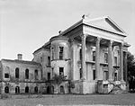
Dorseyville is a census-designated place (CDP) in Iberville Parish, Louisiana, United States, corresponding to the unincorporated community of Dorcyville or Dorseyville. Dorseyville was first listed as a CDP prior to the 2020 census with a population of 159.It is in the southeastern part of the parish, on the southwest bank of the Mississippi River. Louisiana Highway 1 forms the southern edge of the community, leading southeast 1 mile (1.6 km) to White Castle and northwest 9 miles (14 km) to Plaquemine.
Excerpt from the Wikipedia article Dorseyville, Louisiana (License: CC BY-SA 3.0, Authors, Images).Dorseyville, Louisiana
Bucket Drive,
Geographical coordinates (GPS) Address Nearby Places Show on map
 Continue reading on Wikipedia
 Geographical coordinates (GPS)
| Latitude | Longitude |
|---|---|
| N 30.176666666667 ° | E -91.161944444444 ° |
Address
Bucket Drive 56137
70788
Louisiana, United States
Open on Google Maps