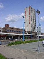
Pendleton railway station

Pendleton (Broad Street) railway station was a railway station serving Pendleton, a district of Salford. It was located on Broughton Road (A576) just behind St. Thomas' Church (Pendleton Church). It was about 100 yards further up Broughton Road from Pendleton Bridge railway station and nearer Pendleton Church and Broad Street (A6). This station was known as Pendleton Broad Street due to its closeness to the A6 Broad Street some 100 yards away. It was on the Manchester Victoria to Wigan Wallgate line with a spur to the Manchester Victoria to Bolton line so trains to Bolton used it after the closure of Pendleton Bridge in 1966, and "Broad Street" was then dropped from its name.
Excerpt from the Wikipedia article Pendleton railway station (License: CC BY-SA 3.0, Authors, Images).Pendleton railway station
Agnew Place, Salford Pendleton
Geographical coordinates (GPS) Address Nearby Places Show on map
Geographical coordinates (GPS)
| Latitude | Longitude |
|---|---|
| N 53.4922 ° | E -2.2841 ° |
Address
Agnew Place
Agnew Place
M6 6WX Salford, Pendleton
England, United Kingdom
Open on Google Maps


