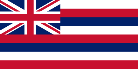
Territory of Hawaii

The Territory of Hawaii or Hawaii Territory (Hawaiian: Panalāʻau o Hawaiʻi) was an organized incorporated territory of the United States that existed from April 30, 1900, until August 21, 1959, when most of its territory, excluding Palmyra Island, was admitted to the United States as the 50th U.S. state, the State of Hawaii. The Hawaii Admission Act specified that the State of Hawaii would not include Palmyra Island, the Midway Islands, Kingman Reef, and Johnston Atoll, which includes Johnston (or Kalama) Island and Sand Island.On July 4, 1898, the United States Congress passed the Newlands Resolution authorizing the U.S. annexation of the Republic of Hawaii, and five weeks later, on August 12, Hawaii became a U.S. territory. In April 1900 Congress approved the Hawaiian Organic Act which organized the territory. United States Public Law 103-150 adopted in 1993, (informally known as the Apology Resolution), acknowledged that "the overthrow of the Kingdom of Hawaii occurred with the active participation of agents and citizens of the United States" and also "that the Native Hawaiian people never directly relinquished to the United States their claims to their inherent sovereignty as a people over their national lands, either through the Kingdom of Hawaii or through a plebiscite or referendum".Hawaii's territorial history includes a period from 1941 to 1944, during World War II, when the islands were placed under martial law. Civilian government was dissolved and a military governor was appointed.
Excerpt from the Wikipedia article Territory of Hawaii (License: CC BY-SA 3.0, Authors, Images).Territory of Hawaii
Saint Louis Drive, East Honolulu Saint Louis Heights
Geographical coordinates (GPS) Address Nearby Places Show on map
Geographical coordinates (GPS)
| Latitude | Longitude |
|---|---|
| N 21.3 ° | E -157.8 ° |
Address
Saint Louis Drive 2417
96816 East Honolulu, Saint Louis Heights
Hawaii, United States
Open on Google Maps


