place

Gomersal railway station

1900 establishments in England1953 disestablishments in EnglandDisused railway stations in West YorkshireFormer London and North Western Railway stationsPages with no open date in Infobox station
Railway stations in Great Britain closed in 1953Railway stations in Great Britain opened in 1900Use British English from March 2021Yorkshire and the Humber railway station stubs
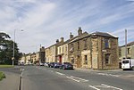
Gomersal railway station (site), Yorkshire (geograph 3821767)

Gomersal railway station served the town of Gomersal, West Yorkshire, England, from 1900 to 1953 on the Leeds New Line.

Excerpt from the Wikipedia article Gomersal railway station (License: CC BY-SA 3.0, Authors, Images).

Gomersal railway station
Queen Street, Kirklees

Geographical coordinates (GPS) Address Nearby Places
placeShow on map

Wikipedia: Gomersal railway stationContinue reading on Wikipedia

Geographical coordinates (GPS)

Latitude Longitude
N 53.7364 ° E -1.684 °
placeShow on map

Address

Queen Street

Queen Street
BD19 4LG Kirklees
England, United Kingdom
mapOpen on Google Maps

Gomersal railway station (site), Yorkshire (geograph 3821767)
Share experience

Nearby Places

West Yorkshire
West Yorkshire

West Yorkshire is a metropolitan and ceremonial county in the Yorkshire and the Humber region of England. It is an inland and upland county having eastward-draining valleys while taking in the moors of the Pennines. West Yorkshire came into existence as a metropolitan county in 1974 after the reorganisation of the Local Government Act 1972 which saw it formed from a large part of the West Riding of Yorkshire. The county had a population of 2.3 million in the 2011 census making it the fourth-largest by population in England. The largest towns are Huddersfield, Castleford, Batley, Bingley, Pontefract, Halifax, Brighouse, Keighley, Pudsey, Morley and Dewsbury. The three cities of West Yorkshire are Bradford, Leeds and Wakefield. West Yorkshire consists of five metropolitan boroughs (City of Bradford, Calderdale, Kirklees, City of Leeds and City of Wakefield); it is bordered by the counties of Derbyshire to the south, Greater Manchester to the south-west, Lancashire to the west and north-west, North Yorkshire to the north and east, South Yorkshire to the south and south-east. Remnants of strong coal, wool and iron ore industries remain in the county, having attracted people over the centuries, and this can be seen in the buildings and architecture. Quite a few railways and the M1, M621, M606, A1(M) and M62 motorways traverse the county. West Yorkshire includes the West Yorkshire Built-up Area, which is the biggest and most built-up urban area within the historic county boundaries of Yorkshire.