place

Tulli, Tampere

Keskusta (Tampere)Pages with Finnish IPAWestern Finland Province geography stubs
Ratapihankatu panoramio

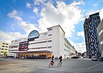
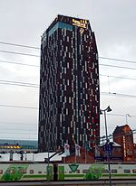
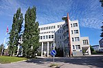
Tulli (Finnish pronunciation: [ˈtulːi]) is a district in the center of Tampere, Finland. It takes its name from the Customs House (Tullikamari) completed in 1901 and the associated Pakkahuone packing house. Due to the proximity of the railway yard, storage, office and production facilities were built in the area from the end of the 19th century. A town plan was established for the area in 1900.Tulli's area houses the premises of the University of Tampere, small industry, the Tullintori shopping center and, to an increasing extent, also settlements. The Customs House and Pakkahuone have restaurant and cultural activities. The northern boundary of Tulli is the Itsenäisyydenkatu street and in the north-south direction it is split by the Yliopistonkatu street. On the eastern edge of the district is the popular recreation area of the eastern center, the Sorsapuisto park, on the southern edge of which is the large concert and congress center, Tampere Hall, completed in 1990. In the western part of Tulli, on the edge of the railway yard and Ratapihankatu, is the tallest hotel building in both Tampere and Finland, Hotel Torni. A new high-rise building, the Tulli Tower (Tullin torni), is planned about 150 meters south of Hotel Torni.

Excerpt from the Wikipedia article Tulli, Tampere (License: CC BY-SA 3.0, Authors, Images).

Tulli, Tampere
Yliopistonkatu, Tampere Tulli (Keskustan suuralue)

Geographical coordinates (GPS) Address Nearby Places
placeShow on map

Wikipedia: Tulli, TampereContinue reading on Wikipedia

Geographical coordinates (GPS)

Latitude Longitude
N 61.496944444444 ° E 23.778888888889 °
placeShow on map

Address

Yliopistonkatu 50
33100 Tampere, Tulli (Keskustan suuralue)
Finland
mapOpen on Google Maps

Ratapihankatu panoramio
Share experience

Nearby Places

Itsenäisyydenkatu
Itsenäisyydenkatu

Itsenäisyydenkatu (literally "Independence Street") is an east–west street in the center of Tampere, Finland. It is a significant street connection in the city center of Tampere in terms of transport connections, as it leads from Tampere's railway station to the Liisankallio district in the Tammela district. On the west side of the station, the street continues as the Hämeenkatu street, at its eastern end it meets Kalevan puistokatu, branching into Teiskontie and Sammonkatu. Today, the only crossroads on Itsenäisyydenkatu with cross-street vehicle traffic is Tammelan puistokatu–Yliopistonkatu. Itsenäisyydenkatu was known from the end of the 19th century until the 1950s as the Puolimatkankatu according to the croft named Puolimatka (literally "half way") located in the area. The impetus for renaming the street was the call made by the state to the cities in 1957 to name a significant street Itsenäisyydenkatu in honor of the 40th anniversary of Finland's independence. The name change took effect in 1958.In 2017, the renovation of the street and the station tunnel began, where the cross-section of the street will be renewed for a tramway to be built in Tampere. The former bus lanes were reserved for the local light rail network so that it runs west of the intersection of Tammelan puistokatu at the south side of the street and east of the intersection in the middle of the street; due to the arrangement, the southern surface of the station tunnel had to be lowered. A bike path was built on the northern edge of the street, and all the aged piping under the street was renewed. The renovation was completed in 2019, and tram traffic will begin in 2021.

Tampere Central Station

Tampere Central Station is a functionalist building in Tampere, Finland, designed by Eero Seppälä and Otto Flodin, completed in 1936. The station is one of the most important railway stations in Finland. In 2015, the Tampere Central Station was the second busiest railway station in Finland in terms of numbers of passengers, after the Helsinki Central Station.The 36-metre clock tower was later added because the Finnish railway bureau required it (its total height from ground level is about 50 metres). The city's main street Hämeenkatu begins at the railway station, continuing over the Hämeensilta bridge to its western end at the Aleksanteri Church. The Itsenäisyydenkatu (originally called Puolimatkankatu) street begins at the Tammela side of the station, continuing to the Kaleva Church. Situated in a central location, the station and its railway yard have served as divisors of the city's districts almost in the same way as Tammerkoski: Tamperean places are often located by saying which side of the station they are on. For decades, there has been discussion of a unified travel centre in Tampere: currently, the long-distance bus terminal, the Tampere Bus Station, is quite far away from the railway station. There are currently three platforms in the Tampere railway station, two of which have a roof. There are five tracks in total, but there are plans to add a fourth platform, making seven tracks in total. The Tampere cargo station is located south from the passenger station. It includes one of the busiest railway organisation yards in Finland. The green building on the east side of the tracks, opposite the old passenger station is the old cargo station. A track leads from the cargo station, over the highway to Helsinki, to the Nekala district, which previously contained many private tracks servicing stock companies. Nowadays, some of the tracks have been disassembled and some are disused. The starting point of the track is used to store train carriages.

Kalevanharju
Kalevanharju

Kalevanharju (lit. 'Kaleva Esker') is a district of Tampere, Finland. It is bordered on the north by Liisankallio, on the northeast by Kaleva, on the east by Kalevanrinne, on the south by Hatanpää, on the west by Ratina and on the northwest by Tulli. The Central Campus of the Tampere University, the Kalevankangas Cemetery and the Tampere Adult Education Center are located in Kalevanharju. On the west side of the cemetery was the State General Hospital, which had moved there from the edge of Nalkala Square in 1910. The hospital, whose main building was in the shape of the letter H, contained features of Art Nouveau and Classicism. To the north of the hospital was the Kalevanharju orphanage, founded in 1925, which included a nursery and a milk distribution station for infants. In the area south and southwest of Kalevanharju, between the Tehdaskatu street and the Viinikanoja ditch, there were several small industrial plants: the Tampere's brewery, founded in 1922, the Tampere box factory, which started operations in 1923, and the Tuotannon leipomo bakery, designed by Frans Jousi, was built in 1927. Tehdaskatu 15, on the other hand, housed Osuusliike Voima's soft drink factory from 1924 onwards.Kalevanharju also has an urban cultivation garden called Kalevanharjun yhteisöviljelmä, where the townspeople grow food plants in cultivation sacks and boxes, experimenting together. The plantation has been in operation since spring 2014 and currently includes about 60 culture sacks and boxes, which are cultivated and cared for by a team of about 15 people.