place

Kalevanharju

Keskusta (Tampere)Western Finland Province geography stubs
Tampereen Aikuiskoulutuskeskus

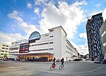
Kalevanharju (lit. 'Kaleva Esker') is a district of Tampere, Finland. It is bordered on the north by Liisankallio, on the northeast by Kaleva, on the east by Kalevanrinne, on the south by Hatanpää, on the west by Ratina and on the northwest by Tulli. The Central Campus of the Tampere University, the Kalevankangas Cemetery and the Tampere Adult Education Center are located in Kalevanharju. On the west side of the cemetery was the State General Hospital, which had moved there from the edge of Nalkala Square in 1910. The hospital, whose main building was in the shape of the letter H, contained features of Art Nouveau and Classicism. To the north of the hospital was the Kalevanharju orphanage, founded in 1925, which included a nursery and a milk distribution station for infants. In the area south and southwest of Kalevanharju, between the Tehdaskatu street and the Viinikanoja ditch, there were several small industrial plants: the Tampere's brewery, founded in 1922, the Tampere box factory, which started operations in 1923, and the Tuotannon leipomo bakery, designed by Frans Jousi, was built in 1927. Tehdaskatu 15, on the other hand, housed Osuusliike Voima's soft drink factory from 1924 onwards.Kalevanharju also has an urban cultivation garden called Kalevanharjun yhteisöviljelmä, where the townspeople grow food plants in cultivation sacks and boxes, experimenting together. The plantation has been in operation since spring 2014 and currently includes about 60 culture sacks and boxes, which are cultivated and cared for by a team of about 15 people.

Excerpt from the Wikipedia article Kalevanharju (License: CC BY-SA 3.0, Authors, Images).

Kalevanharju
Sairaalankatu, Tampere Kalevanharju (Keskustan suuralue)

Geographical coordinates (GPS) Address Nearby Places
placeShow on map

Wikipedia: KalevanharjuContinue reading on Wikipedia

Geographical coordinates (GPS)

Latitude Longitude
N 61.493333333333 ° E 23.783888888889 °
placeShow on map

Address

Sairaalankatu 6
33100 Tampere, Kalevanharju (Keskustan suuralue)
Finland
mapOpen on Google Maps

Tampereen Aikuiskoulutuskeskus
Share experience

Nearby Places

Viinikka
Viinikka

Viinikka is a district of Tampere, Finland, located 1,5 kilometers southeast of its city center on the west side of Lake Iides. Its neighboring district is Nekala. Its construction began in 1914 on the former lands of Hatanpää Manor. The stone church, opened in 1932, is located in Viinikka.Viinikka's main streets are Viinikankatu in a north–south direction and Kuokkamaantie in a west–east direction from Lempääläntie to Nekala. The original name of Viinikankatu in 1939–1956 was Hervannantie, but the name was considered misleading because Hervanta is located quite far from the Viinikka district. Before the major street name reform carried out in Tampere in 1936, the current Tuomiokirkonkatu in the center of Tampere was known as Viinikankatu. Ahlmanintie, on the east side of Viinikankatu, is named after Gabriel Ahlman (1737–1799), an assessor who owned the Hatanpää Manor in the late 18th century. The land register of 1540 mentioned the village of Otavala, which belonged to Messukylä, where the houses of Otavala and Viinikka were located. The name Viinikka is thought to be of German origin. In 1757, Otavala passed to Hans Henrik Boije (1716–1781), the owner of the Hatanpää Manor and member of Parliament, who established a spinning school and a flax weaving mill on the farm. The school, called the “Otavalan spinni”, was designed to teach the handling of flax from sowing the seed to weaving the fabric. The spinning school, which had become a pawn of party politics at the time, was closed down after only a few years of operation, but it had time to pave the way for the flax mills established in Tampere in the 19th century. The Viinikka area was annexed to the city of Tampere after the Hatanpää Manor became the property of the city in 1913 and was reserved for a detached house. Viinikka's first town plan was approved in 1914, when the area was bounded on the north by Viinikanoja, on the east by Lake Iides and the Pahaoja pond, on the south by Pahalampi and on the west by the Riihimäki–Tampere railway. The town plans of the area were not finally approved until 1936–1954.

Itsenäisyydenkatu
Itsenäisyydenkatu

Itsenäisyydenkatu (literally "Independence Street") is an east–west street in the center of Tampere, Finland. It is a significant street connection in the city center of Tampere in terms of transport connections, as it leads from Tampere's railway station to the Liisankallio district in the Tammela district. On the west side of the station, the street continues as the Hämeenkatu street, at its eastern end it meets Kalevan puistokatu, branching into Teiskontie and Sammonkatu. Today, the only crossroads on Itsenäisyydenkatu with cross-street vehicle traffic is Tammelan puistokatu–Yliopistonkatu. Itsenäisyydenkatu was known from the end of the 19th century until the 1950s as the Puolimatkankatu according to the croft named Puolimatka (literally "half way") located in the area. The impetus for renaming the street was the call made by the state to the cities in 1957 to name a significant street Itsenäisyydenkatu in honor of the 40th anniversary of Finland's independence. The name change took effect in 1958.In 2017, the renovation of the street and the station tunnel began, where the cross-section of the street will be renewed for a tramway to be built in Tampere. The former bus lanes were reserved for the local light rail network so that it runs west of the intersection of Tammelan puistokatu at the south side of the street and east of the intersection in the middle of the street; due to the arrangement, the southern surface of the station tunnel had to be lowered. A bike path was built on the northern edge of the street, and all the aged piping under the street was renewed. The renovation was completed in 2019, and tram traffic will begin in 2021.