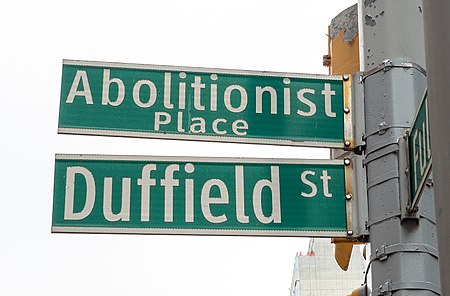
Abolitionist Place

Abolitionist Place is an alternative name for a section of Duffield Street in Brooklyn, New York City, which was a significant site of abolitionist activity in the 19th century. Abolitionists Harriet and Thomas Truesdell lived at 227 Duffield Street, which is believed to have been a stop on the Underground Railroad. William Harned, an Underground Railroad conductor, lived at the intersection with Willoughby Street, and stories have been passed down orally of involvement of several houses on the block. Duffield Street is said to be named for John Duffield, a Brooklyn resident and surgeon during the American Revolutionary War.In the mid-2000s the New York City Economic Development Corporation (NYCEDC) announced plans to use eminent domain to seize and demolish the sites to construct a new public square and underground parking, leading the community to organize in opposition. Amid the pushback, the city renamed the street Abolitionist Place while proceeding with development plans. By 2019, all but one of the sites with claimed abolitionist activity on the street were demolished. The last, 227 Duffield, was designated as a landmark by the New York City Landmarks Preservation Commission in 2021. A public space at the intersection with Willoughby Street, also named Abolitionist Place, is in development as of June 2021.
Excerpt from the Wikipedia article Abolitionist Place (License: CC BY-SA 3.0, Authors, Images).Abolitionist Place
Duffield Street, New York Brooklyn
Geographical coordinates (GPS) Address Nearby Places Show on map
Geographical coordinates (GPS)
| Latitude | Longitude |
|---|---|
| N 40.691388888889 ° | E -73.984166666667 ° |
Address
Duffield Street 227
11201 New York, Brooklyn
New York, United States
Open on Google Maps


