place

Steele Burnand Anza-Borrego Desert Research Center

Anza-Borrego Desert State ParkCalifornia university stubsEcology stubsResearch institutes in CaliforniaSan Diego County, California
San Diego County, California geography stubsUniversity of California, IrvineUniversity of California Natural Reserve SystemUse American English from January 2021Use mdy dates from January 2021

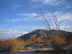
The Steele Burnand Anza-Borrego Desert Research Center is a research center at the Anza-Borrego Desert State Park in southern California. The facility is a spawn of the joint partnership between the University of California, Irvine, the Anza-Borrego Foundation, and the administration of the state park. UC Irvine originally had facilities on 3.75 acres of land in the area, and their reach was expanded by a 75-acre donation from the Anza-Borrego Foundation. The facility was formerly a country club. The complex includes a hall, two classrooms, a laboratory, and a kitchen. The area in which the facility is located receives 5-7 inches of rain per year.

Excerpt from the Wikipedia article Steele Burnand Anza-Borrego Desert Research Center (License: CC BY-SA 3.0, Authors).

Steele Burnand Anza-Borrego Desert Research Center
Tilting T Drive,

Geographical coordinates (GPS) Address Website Nearby Places
placeShow on map

Wikipedia: Steele Burnand Anza-Borrego Desert Research CenterContinue reading on Wikipedia

Geographical coordinates (GPS)

Latitude Longitude
N 33.240633205931 ° E -116.38878929151 °
placeShow on map

Address

Steele/Burnand Anza-Borrego Desert Research Center

Tilting T Drive 401
92004
California, United States
mapOpen on Google Maps

Website
ucnrs.org

linkVisit website

Share experience

Nearby Places

Borrego Sink
Borrego Sink

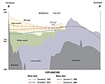
San Gregorio campsite at the Borrego Sink in the Borrego Valley, Borrego Springs, California in San Diego County, is a California Historical Landmark No. 673 listed on February 16, 1959. The San Gregorio campsite was a desert camp for the Spanish Commander Juan Bautista de Anza's expedition of 1775 and 1776. The expedition passed through the Imperial Valley then through the Colorado Desert, now the Anza-Borrego Desert State Park. The expedition's goal was to start Spanish missions in California and presidio forts through Las Californias to the San Francisco Bay. The expedition route is now the Juan Bautista de Anza National Historic Trail. At the Anza San Gregorio campsite in the Colorado Desert, the Anza Expeditions stopped and dug deep wells in a dry wash to get water for the expedition and its stock of mules, cattle, and 140 horses. The underground water at Borrego Sink comes when Coyote Creek is flowing, Coyote Creek runs down the valley into Borrego Sink. During rain storms the Borrego Sink can turn in to a swallow lake or a vast mud flat. Coyote Creek is the only reliably perennial creek in Anza-Borrego Desert State Park. Coyote Creek is 18 miles (29 km) long and runs from the city of Anza, California to Borrego Sink. Borrego Sink is at an elevation of 455 feet (138 meters) at the low spot of the Borrego Valley. Coyote Creek supports Desert bighorn sheep and a desert riparian zone. Coyote Creek is divided up into three zones Upper Willows, Middle Willows, and Lower Willows. The Coyote Creek riparian zone supports: narrow-leaf willow (Salix exigua), Fremont cottonwood (Populus fremontii), western sycamore (Platanus racemosa), arrowweed (Tessaria sericea), white alder (Alnus rhombifolia), mulefat (Baccharis glutinosa), honey mesquite (Prosopis glandulosa), and tamarisk (Tamarix ramosissima an invasive species). In a few spots palms (Washingtonia filifera) grow. Coyote Creek riparian zone supports seasonal birds: Bell's vireo, Black-crowned night heron, green-backed heron, common yellowthroat, American kestrel, yellow-breasted chat, black-tailed gnatcatcher, blue grosbeak, downy woodpecker, willow flycatcher, yellow warbler, prairie falcon, red-shouldered hawk, and the black-shouldered kite. The Cahuilla tribe lived along Coyote Creek in the past.A Historical marker is near the campsite in the desert at Borrego Sink, 3 Miles Southeast of Palm Canyon and Peg Leg Roads in Anza-Borrego Desert State Park.