place

Cold Hanworth

Civil parishes in LincolnshireUse British English from October 2014Villages in LincolnshireWest Lindsey District
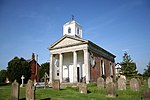
All Saints' church, Cold Hanworth geograph.org.uk 195630

Cold Hanworth is a village and civil parish in the West Lindsey district of Lincolnshire, England. It is situated 8 miles (13 km) north-north-east from the city and county town of Lincoln, and just north of the A46. It is combined with Hackthorn to form the parish council of Hackthorn and Cold Hanworth. The cruciform church of All Saints was rebuilt in 1861, replacing one of medieval origin. The Grade II listed building was converted to a private house and renamed Old Church House in 1966. It has been disused since 1973. A further listed building is a farm cottage on Green Lane.At the south of the village are the earthwork remains of Cold Hanworth medieval village. This settlement was established in the 11th century but abandoned by the 18th.Cold Hanworth Forge is a working forge and blacksmithing school.

Excerpt from the Wikipedia article Cold Hanworth (License: CC BY-SA 3.0, Authors, Images).

Cold Hanworth
Main Street, West Lindsey

Geographical coordinates (GPS) Address Nearby Places
placeShow on map

Wikipedia: Cold HanworthContinue reading on Wikipedia

Geographical coordinates (GPS)

Latitude Longitude
N 53.336674 ° E -0.448576 °
placeShow on map

Address

Main Street

Main Street
LN2 3RF West Lindsey
England, United Kingdom
mapOpen on Google Maps

All Saints' church, Cold Hanworth geograph.org.uk 195630
Share experience

Nearby Places

Dunholme
Dunholme

Dunholme is a village and civil parish in the West Lindsey district of Lincolnshire, England. It is situated on the A46 road, and 5 miles (8 km) north-east of Lincoln. The earliest written evidence concerning Dunholme is found in the 1086 Domesday Book.The village stands almost exactly in the centre of its parish, on the banks of the Welton Beck, which follows into the village from Welton in the north.There are multiple theories on the origins of the village's name. One presented in The Place and River Names of the West Riding of Lindsey is that the name of the village is derived from "Dunham" from 'dun' meaning hill, and 'ham' meaning river bend. An alternative origin by Ekwall suggests the name came from "Donna's ham", meaning the 'ham' or enclosure of Dunna, possible an Anglo-Saxon.Within the village, Dunholme has a post office, a village shop, St Chad's CE Primary School on Ryland Road. William Farr C of E Comprehensive School is partially located within the parish boundary and is accessible from Honeyholes Lane in the village of Dunholme, however the main entrance is located on Lincoln Road in Welton.The parish church is dedicated to Saint Chad, and is a Grade I listed building, built in Early English style. It contains a kneeling effigy to Robert Grantham (died 1616), which was restored in 1856 and 1892. The church forms part of the benefice of Welton, Dunholme and Scothern. The rood screen was carved by the Congolese sculptor Mahomet Thomas Phillips.RAF Dunholme Lodge airfield was used by RAF Bomber Command during the Second World War. It closed in 1964 and little remains. Some of the land was purchased by Rev William Farr in 1946 for the site of William Farr School. Every summer, the village holds a village fête. The fête is held in the centre of the village near the church and involves a duck race alongside many other activities. The village has a camera club.