Mildred Island
Islands of Northern CaliforniaIslands of San Joaquin County, CaliforniaIslands of the Sacramento–San Joaquin River DeltaSan Joaquin Valley geography stubs

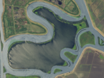
Mildred Island is a submerged island in the San Joaquin River delta, in California. It is part of San Joaquin County. It flooded in 1983, and the land was abandoned. Its coordinates are 37.9863117°N 121.5230069°W / 37.9863117; -121.5230069 (Mildred Island). It appears on 1913 and 1952 United States Geological Survey maps of the area.
Excerpt from the Wikipedia article Mildred Island (License: CC BY-SA 3.0, Authors, Images).Mildred Island
Geographical coordinates (GPS) Address Nearby Places Show on map
Geographical coordinates (GPS)
| Latitude | Longitude |
|---|---|
| N 37.9863117 ° | E -121.5230069 ° |
Address
San Joaquin County (San Joaquin)
California, United States
Open on Google Maps


