place

Albanian Mosque, Dandenong

1968 establishments in AustraliaAlbanian diasporaBuildings and structures in the City of Greater DandenongDandenong, VictoriaMosques completed in 1968
Mosques in MelbourneUse Australian English from August 2020
Albanian Mosque (Dandenong) 6

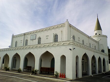
The Albanian Mosque (Albanian: Xhamija Shqiptare Dandenong Këshavë), also known as the Albanian Islamic Centre Mosque and Albanian Sakie Islamic Centre, is a mosque located in Dandenong, a south eastern suburb of Melbourne, Victoria, Australia. It is one of the earliest mosques in the country.The mosque is a large building, built next to Dandenong Creek and residential neighbourhood, with a minaret, and community facilities. Associated with the Albanian Australian community, the mosque is owned by and the centre of the Albanian Sakie Islamic Society of Dandenong.

Excerpt from the Wikipedia article Albanian Mosque, Dandenong (License: CC BY-SA 3.0, Authors, Images).

Albanian Mosque, Dandenong
Dalgety Street, Melbourne Dandenong

Geographical coordinates (GPS) Address Nearby Places
placeShow on map

Wikipedia: Albanian Mosque, DandenongContinue reading on Wikipedia

Geographical coordinates (GPS)

Latitude Longitude
N -37.994182 ° E 145.208464 °
placeShow on map

Address

Dalgety Street
3175 Melbourne, Dandenong
Victoria, Australia
mapOpen on Google Maps

Albanian Mosque (Dandenong) 6
Share experience

Nearby Places

Shepley Oval
Shepley Oval

Shepley Oval is a football and cricket field located in Dandenong in south-eastern Melbourne. It presently serves as the home ground of the Dandenong Cricket Club in the Victorian Premier Cricket competition, and of the Dandenong Stingrays in the TAC Cup football competition. Shepley Oval is located at the eastern end of Dandenong Park, immediately north of the Dandenong Creek. The parkland was used for sports in the late 19th century, but throughout the early half of the 20th century until the 1960s, the premier venue for sports in Dandenong was the Dandenong Showgrounds (which at that time was located in Clow Street, the site presently occupied by the Dandenong Municipal Offices). Shepley Oval was developed to a top standard oval in the late 1950s, with a grandstand being opened in 1959, and it has been the region's premier sports venue since the 1960s.The venue's most historically notable football tenant is the Dandenong Football Club. Dandenong, which was then playing in the Victorian Football Association, moved its home ground from the Showgrounds to Shepley Oval in 1962, and played its games there until it folded at the end of the 1994 season. In 1995, the Southern Stingrays in Victoria's premier under-18s football competition, the TAC Cup, moved its home ground from Kavanagh Reserve, Mordialloc to Shepley Oval; the club has been since known as the Dandenong Stingrays, remains based at the ground in 2014 and is now the main football tenant of the oval. Another notable football tenant of the ground was the Victorian Football League's Springvale Football Club, which played many of its games at the ground between 2000 and 2005, after it had left the Newcomen Rd Oval but before it moved to Casey Fields.In the early 1960s, around the same time as the Dandenong Football Club moved to Shepley Oval, the Dandenong Sub-District Cricket Club was formed, and began playing its games at Shepley Oval during the summer. Top level district cricket first came to the venue in 1989, when the Waverley Cricket Club merged with Dandenong; the merged club, originally known as Waverley-Dandenong but now known as the Dandenong Cricket Club, has played its first XI and second XI cricket at Shepley Oval since; Wilson Oval, which is adjacent to Shepley Oval in Dandenong Park, serves as the third and fourth XI home ground.The venue is named after former Dandenong Cricket Association secretary and president Harry Shepley. The oval has two main buildings: the Frank Storan Grandstand, named after the Dandenong cricket personality whose fundraising efforts facilitated its construction; and the Keith Miller Pavilion, named after the former Dandenong mayor, footballer and cricketer Keith Esmond Miller – not after former Australian Test cricketer and VFL footballer Keith Ross Miller, who was a much better known sportsman from Melbourne, but had no association with sport in Dandenong. The Keith Miller Pavilion underwent a $1.25 million re-development in 2014 to improve its training facilities. The ornate western gates were originally built at the Springvale Crematorium and were moved to Shepley Oval later.
Dandenong, Victoria
Dandenong, Victoria

Dandenong ( DAN-di-nong) is a southeastern suburb of Melbourne, Victoria, Australia, about 35 km (22 mi) from the Melbourne CBD. It is the council seat of the City of Greater Dandenong local government area, with a recorded population of 30,127 at the 2021 census. Situated mainly on the northwest bank of the lower Dandenong Creek, it is 21.6 km (13.4 mi) from the eponymous Dandenong Ranges to its northeast and completely unrelated in both location and nature of the settlement. A regional transport hub and manufacturing centre of Victoria, Dandenong is located at the junctional region of the Dandenong Valley Highway, Princes Highway, Monash Freeway and Dingley Freeway, and is the gateway town of the Gippsland railway line into West Gippsland. It is directly neighboured from the north and south by two sister suburbs Dandenong North and Dandenong South, from the east by Doveton, and from the northwest and southwest by Noble Park and Keysborough, respectively. The easternmost and westernmost neighbourhoods of suburb are also unofficially named Dandenong East and Dandenong West, separated from the main portions of the suburb by Stud Road and Princes Highway, and Cheltenham Road and Gladstone Road/Jones Road/Bennet Street, respectively. Dandenong began as a township in 1852 and at the start of the 20th century was an important regional city with its own suburbs. During the mid-20th century it became a major manufacturing and commercial area, and eventually an incorporated satellite city of the expanding Greater Melbourne conurbation. A business district, the former town centre, covers much of its area and is one of the largest in Greater Melbourne. It is currently undergoing major transit-oriented urban renewal, which was first planned in the Melbourne 2030 strategy.

Yarraman railway station

Yarraman railway station is a minor commuter railway station on the Pakenham and Cranbourne lines of the metropolitan railway network in Victoria, Australia, located about 27 km (17 mi) from the Melbourne CBD. It serves neighbourhoods between the south-eastern Melbourne suburbs of Noble Park and Dandenong, and is named after the nearby Yarraman Creek, a first-order tributary of the lower Dandenong Creek/Patterson River system. The EastLink toll road is located near the down (south-eastern) end of the station, crossing the line via an overpass. The EastLink Trail, which follows the tollway, uses the entrance footbridge of the station to traverse the railway. The station was opened on 21 December, 1976. To allow its construction, the existing up track was slewed in 1974. At that time, an alternative name for the station, "Fotheringham", was suggested, to recognise a notable local family.In 2015, the Level Crossing Removal Project announced the grade separation of the nearby Chandler Road level crossing. Construction began in 2016, with the level crossing removed and a railway overpass built over the road by 2018. Unlike many stations between Noble Park and Caulfield, that were elevated on viaducts as part of the level crossing removal project, the tracks between Dandenong and Noble Park largely remained at ground level. Yarraman station was not rebuilt because it is over 500 metres away from the Chandler Road viaduct.