Punkendeich
Bremen (city)Red-light districts in GermanyUse British English from May 2020
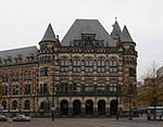
The Punkendeich was a dike (floodbank) between the river Weser and the city of Bremen that was known for prostitution. It ran from the city wall (Altenwall) to Sielwall (today's Deichstraße to Siel am Dobben). Originally called the Sieldeich, the Punkendeich was incorporated into the larger Osterdeich in 1850. A road and houses were built along the top of the dike, the road later becoming part of the Osterdeich trunk road.
Excerpt from the Wikipedia article Punkendeich (License: CC BY-SA 3.0, Authors).Punkendeich
Osterdeich, Stadtgebiet Bremen Mitte (Bremen-Mitte)
Geographical coordinates (GPS) Address Nearby Places Show on map
Geographical coordinates (GPS)
| Latitude | Longitude |
|---|---|
| N 53.07108 ° | E 8.81308 ° |
Address
Osterdeich
Osterdeich
28195 Stadtgebiet Bremen, Mitte (Bremen-Mitte)
Free Hanseatic City of Bremen, Germany
Open on Google Maps


