place

City of Doncaster

1974 establishments in EnglandIncomplete lists from June 2019Local government districts in South YorkshireMetropolitan Borough of DoncasterMetropolitan boroughs
Politics of DoncasterUse British English from April 2018
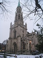
St George's Church, Doncaster geograph.org.uk 426776

The City of Doncaster is a metropolitan borough with city status in South Yorkshire, England. It is named after its principal settlement, Doncaster, and includes the surrounding suburbs of Doncaster as well as numerous towns and villages. The district has large amounts of countryside; at 219 square miles (570 km2), it is the largest metropolitan borough in England by area. The largest settlement in the borough are Doncaster itself, followed by the towns of Thorne, Hatfield and Mexborough (the latter of which is part of the Barnsley/Dearne Valley built-up area), and it additionally covers the towns of Conisbrough, Stainforth, Bawtry, Askern, Edlington and Tickhill. Doncaster borders North Yorkshire to the north, the East Riding of Yorkshire to the north-east, North Lincolnshire to the east, Bassetlaw in Nottinghamshire to the south-east, Rotherham to the south-west, Barnsley to the west, and Wakefield, West Yorkshire, to the north-west. It is part of the Yorkshire and the Humber region. The borough was created on 1 April 1974, under the Local Government Act 1972, as a merger of the former County Borough of Doncaster, the urban districts of Adwick-le-Street, Bentley with Arksey, Conisbrough, Mexborough, and Tickhill, Doncaster and Thorne rural districts, and the parish of Finningley from East Retford Rural District and small parts of the parish of Harworth from Worksop Rural District from Nottinghamshire.

Excerpt from the Wikipedia article City of Doncaster (License: CC BY-SA 3.0, Authors, Images).

City of Doncaster
Prince's Street, Doncaster Hyde Park

Geographical coordinates (GPS) Address Nearby Places
placeShow on map

Wikipedia: City of DoncasterContinue reading on Wikipedia

Geographical coordinates (GPS)

Latitude Longitude
N 53.5225 ° E -1.1286111111111 °
placeShow on map

Address

Iceland

Prince's Street
DN1 3NJ Doncaster, Hyde Park
England, United Kingdom
mapOpen on Google Maps

St George's Church, Doncaster geograph.org.uk 426776
Share experience

Nearby Places

Mansion House, Doncaster

Doncaster Mansion House is a Grade I listed building in Doncaster, South Yorkshire, England. It is owned and managed by Doncaster Council. The Mansion House stands on the site of the Carmelite Friary, which had been established in Doncaster in 1350 and remained until its dissolution on 13 November 1538, after which the buildings were destroyed. During the 18th century, Doncaster's position on the Great North Road brought wealth to the town. The town's corporation was frequently called on to host entertainments, initially at the mayor's house or the Angel or Three Cranes inns. In 1719, they took a lease on a house in the High Street for holding feasts, but let this lapse around 1727. They bought a site on the High Street in 1738, with the intention of building a permanent base for entertaining, but little construction took place for several years. In 1746, James Paine was appointed as architect in 1746. Although young, Paine had already worked on Nostell Priory and had designed Heath House, both near Wakefield.Mansion Houses had already been constructed in Newcastle upon Tyne (now demolished), York and London. Whereas these other buildings contained both formal reception rooms and living quarters for the mayor, Doncaster's differed in being designed purely for entertainment, although some later mayors used space in the building as accommodation.Paine planned a building along the now established designs of Assembly Rooms. It was completed in 1748 and officially opened in 1749, the construction having cost £8,000. Paine was immediately offered more local work, starting with alterations to Cusworth Hall. He published his designs for the Mansion House in 1751. This work showed the building flanked by two other structures, marked as houses for the town clerk and recorder, but these were never part of the commission and were not built.William Lindley extended the building between 1801 and 1806, adding an attic storey, a rear banqueting hall and rear landing.