place

Queens is the Future
2007 establishments in New York CityJackson Heights, QueensMurals in New York CityTrains in art
Queens Is The Future

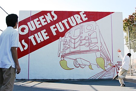
Queens is the Future is a mural created in 2007 by married artists Eve Biddle and Joshua Frankel. It is located on a handball court in the schoolyard of I.S. 145, a public middle school in Jackson Heights, Queens. The mural originally depicted a subway car blasting off of its tracks as though powered by rocket fuel, with the words “Queens is the Future” painted in the upper left corner. It quickly became an iconic image of the borough, inspiring the Municipal Art Society to name their walking tour of neighborhood after the work, as well as appearing in Sports Illustrated, Time Out New York, and a short documentary about the rise of Bronx and Queens Rep. Alexandria Ocasio-Cortez.In January 2015, without consulting the original artists, Sony Pictures altered the mural, inserting Spider-Man into the image, to promote the release of the film The Amazing Spider-Man 2.The mural was restored in 2022.

Excerpt from the Wikipedia article Queens is the Future (License: CC BY-SA 3.0, Authors, Images).

Queens is the Future
Northern Boulevard, New York Queens County

Geographical coordinates (GPS) Address Nearby Places
placeShow on map

Wikipedia: Queens is the FutureContinue reading on Wikipedia

Geographical coordinates (GPS)

Latitude Longitude
N 40.755166666667 ° E -73.887444444444 °
placeShow on map

Address

Northern Boulevard
11372 New York, Queens County
New York, United States
mapOpen on Google Maps

Queens Is The Future
Share experience

Nearby Places

Jackson Heights, Queens

Jackson Heights is a neighborhood in the northwestern portion of the borough of Queens in New York City. Jackson Heights is neighbored by North Corona to the east, Elmhurst to the south, Woodside to the west, northern Astoria (Ditmars-Steinway) to the northwest, and East Elmhurst to the north and northeast. Jackson Heights has an ethnically diverse community, with half the population having been foreign-born since the 2000s. The New York Times has described Jackson Heights as "the most culturally diverse neighborhood in New York, if not on the planet." According to the 2010 United States Census, the neighborhood has a population of 108,152. The site of Jackson Heights was a vast marsh named Trains Meadow until 1909 when Edward A. MacDougall's Queensboro Corporation bought 325 acres (132 ha) of undeveloped land and farms. The Queensboro Corporation named the land Jackson Heights after John C. Jackson, a descendant of one of the original Queens families and a respected Queens entrepreneur. Further development arose through the development of transit, and "garden apartments" and "garden homes" soon became prevalent in Jackson Heights. During the 1960s, Jackson Heights' white middle-class families began moving to the suburbs, and non-white residents began moving in. Jackson Heights retains much of its residential character in the modern day. It also has numerous commercial establishments clustered around 37th Avenue, as well as along several side streets served by subway stations. Much of the neighborhood is part of a national historic district called the Jackson Heights Historic District, which was listed on the National Register of Historic Places in 1999. Part of the neighborhood was placed on a New York City historic district of the same name in 1993. Jackson Heights is located in Queens Community District 3 and its ZIP Code is 11372. The zip code 11370 is co-named with East Elmhurst. It is patrolled by the New York City Police Department's 115th Precinct. Politically, Jackson Heights is represented by the New York City Council's 21st and 25th districts.

Holmes Airport

Holmes Airport (occasionally known as Grand Central Air Terminal and Grand Central Airport) was an airport in the Jackson Heights neighborhood of Queens in New York City that operated from 1929 to 1940. Real estate developer E. H. Holmes built the airport on approximately 220 acres (89 ha) of undeveloped land. He organized and sold stock in Holmes Airport, Inc., but claimed that some wanted to see him fail. In February, 1929, Clarence D. Chamberlin, the aviator Viola Gentry, and Dorothy Stone, actress and daughter of Fred Stone, broke ground for the new airport. According to a contemporary street map, it extended as far as 79th Street to the east, 68th Street and St. Michael's Cemetery to the west, Astoria Boulevard to the north, and 31st Avenue to the south. The airport had two hangars, an office, and two gravel runways, of 2,800 feet (853 m) and 3,000 feet (914 m) in length, respectively.The new airport opened on Saturday, March 16, 1929, attracting 100,000 visitors on its second day of operation. Later that year, the first scheduled flights from New York City began when Eastern Air Express started a two-day service to Miami from Holmes.In April 1930, thousands of people paid $1 each (equivalent to $16 in 2021) for a ride in an airplane. It was promoted as an experiment to ascertain whether it was fear or the expense that kept the public from flying.On Sunday, November 11, 1934, sixty-four airplanes took part in a 30-mile (48 km) novelty race involving a treasure hunt and pie-eating contest, the winner returning in 28 minutes.Blimps also used the airport. Goodyear erected a 220-foot-long (67 m) hangar in 1931 and conducted sightseeing flights. In 1936, a Goodyear blimp based at Holmes Airport provided the first aerial traffic reports.In 1937, the airport's owners sought a court injunction to stop New York City from spending $8,444,300 (equivalent to $159,000,000 in 2021) to develop the smaller North Beach Airport, only a mile or so to the northeast, into the much larger LaGuardia Airport. Supreme Court Justice Ernest E. L. Hammer denied the request. LaGuardia Airport opened in 1939 and Holmes Airport closed the following year.The northern portion of Holmes Airport's land was later developed into veteran housing and the Bulova watch factory site.