1929 Palestine riots

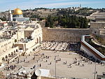
The 1929 Palestine riots, Buraq Uprising (Arabic: ثورة البراق, Thawrat al-Buraq) or the Events of 1929 (Hebrew: מאורעות תרפ"ט, Meora'ot Tarpat, lit. Events of 5689 Anno Mundi), was a series of demonstrations and riots in late August 1929 in which a longstanding dispute between Muslims and Jews over access to the Western Wall in Jerusalem escalated into violence. The riots took the form, for the most part, of attacks by Arabs on Jews accompanied by destruction of Jewish property. During the week of riots, from 23 to 29 August, 133 Jews were killed by Arabs, and 339 Jews were injured, most of whom were unarmed. There were 116 Arabs killed and at least 232 wounded, mostly by the Mandate police suppressing the riots. Around 20 Arabs were killed by Jewish attackers and indiscriminate British gunfire. After the riots, 174 Arabs and 109 Jews were charged with murder or attempted murder; around 40% of Arabs and 3% of Jews were subsequently convicted. During the riots, 17 Jewish communities were evacuated.The British-appointed Shaw Commission found that the fundamental cause of the violence, "without which in our opinion disturbances either would not have occurred or would have been little more than a local riot, is the Arab feeling of animosity and hostility towards the Jews consequent upon the disappointment of their political and national aspirations and fear for their economic future", as well as Arab fears of Jewish immigrants "not only as a menace to their livelihood but as a possible overlord of the future". With respect to the triggering of the riots, the Commission found that the incident that "contributed most to the outbreak was the Jewish demonstration at the Wailing Wall on 15 August 1929".Avraham Sela described the riots as "unprecedented in the history of the Arab-Jewish conflict in Palestine, in duration, geographical scope and direct damage to life and property".
Excerpt from the Wikipedia article 1929 Palestine riots (License: CC BY-SA 3.0, Authors, Images).1929 Palestine riots
Heil HaHandasa, Jerusalem Morasha
Geographical coordinates (GPS) Address Nearby Places Show on map
Geographical coordinates (GPS)
| Latitude | Longitude |
|---|---|
| N 31.776666666667 ° | E 35.234166666667 ° |
Address
העיר העתיקה
Heil HaHandasa
9511208 Jerusalem, Morasha
Jerusalem District, Israel
Open on Google Maps


