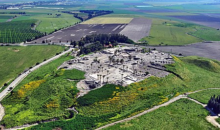
Tel Megiddo

Tel Megiddo (Hebrew: תל מגידו; Arabic: مجیدو, Tell el-Mutesellim, lit. "Mound of the Governor"; Greek: Μεγιδδώ, Megiddo) is the site of the ancient city of Megiddo, the remains of which form a tell (archaeological mound), situated in northern Israel near Kibbutz Megiddo, about 30 kilometres (19 mi) south-east of Haifa, at the western edge of Jezreel Valley. Megiddo is known for its historical, geographical, and theological importance, especially under its Greek name Armageddon. During the Bronze Age, Megiddo was an important Canaanite city-state. During the Iron Age, it was a royal city in the Kingdom of Israel. Megiddo drew much of its importance from its strategic location at the northern end of the Wadi Ara defile, which acts as a pass through the Carmel Ridge, and from its position overlooking the rich Jezreel Valley from the west. Excavations have unearthed 20 strata of ruins since the Neolithic phase, indicating a long period of settlement. The site is protected as Megiddo National Park and is a World Heritage Site.
Excerpt from the Wikipedia article Tel Megiddo (License: CC BY-SA 3.0, Authors, Images).Tel Megiddo
66, Megido Regional Council
Geographical coordinates (GPS) Address Website External links Nearby Places Show on map
Geographical coordinates (GPS)
| Latitude | Longitude |
|---|---|
| N 32.585277777778 ° | E 35.184444444444 ° |
Address
גן לאומי תל מגידו
66
Megido Regional Council
North District, Israel
Open on Google Maps


