place

Temple Church, Bristol
12th-century church buildings in EnglandChurch ruins in EnglandChurches bombed by the Luftwaffe in BristolChurches completed in 1460English Heritage sites in Bristol
Former churches in BristolGrade II* listed churches in BristolGrade II* listed ruinsInclined towersRuins in BristolRuins of churches destroyed during World War IIScheduled monuments in BristolTourist attractions in BristolTowers completed in the 15th centuryUse British English from February 2023
Temple Church Bristol Jan10

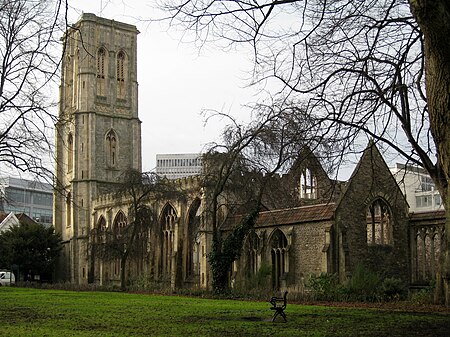
Temple Church, also known as Holy Cross Church, (grid reference ST5972) is a ruined church in Redcliffe, Bristol, England. It is on the site of a previous, round church of the Knights Templar, which they built on land granted to them in the second quarter of the 12th century by Robert of Gloucester. In 1313 the Knights Hospitaller acquired the church, following the suppression of the Templars, only to lose it in 1540 at the time of the Dissolution of the Monasteries. By the early 14th century, the church served as the parish church for the area known as Temple Fee. From around the same time, the rebuilding of the church on a rectangular plan started. This was completed by 1460, with the construction of a leaning west tower. The church was the scene of the exorcism of George Lukins conducted by Methodist and Anglican clergy in 1788.The church was bombed and largely destroyed in the Bristol Blitz. It is a Grade II* listed building, owned by the Diocese of Bristol. In 1958, English Heritage agreed to undertake a guardianship role. A 1960 excavation by the Ministry of Works discovered the plan of the 12th-century church, enabling it to be marked out on the ground in stone.

Excerpt from the Wikipedia article Temple Church, Bristol (License: CC BY-SA 3.0, Authors, Images).

Temple Church, Bristol
Petticoat Lane, Bristol Redcliffe

Geographical coordinates (GPS) Address External links Nearby Places
placeShow on map

Wikipedia: Temple Church, BristolContinue reading on Wikipedia

Geographical coordinates (GPS)

Latitude Longitude
N 51.452 ° E -2.587 °
placeShow on map

Address

Temple Church (Holy Church;Holy Cross)

Petticoat Lane
BS1 6DE Bristol, Redcliffe
England, United Kingdom
mapOpen on Google Maps

linkWikiData (Q1253118)
linkOpenStreetMap (1710200)

Temple Church Bristol Jan10
Share experience

Nearby Places

Finzels Reach
Finzels Reach

Finzels Reach is a 4.7-acre (1.9 ha) mixed use development site located in central Bristol, England, on a former industrial site, which occupies most of the south bank of Bristol Floating Harbour between Bristol Bridge and St Philip's Bridge, across the river from Castle Park. A sugar refinery occupied part of the site from 1681, rebuilt by Conrad Finzel I in 1846 to become one of the largest sugar refineries in England. Known as Finzel's Sugar Refinery, it operated until 1881. Georges Bristol Brewery, founded in 1788, grew to occupy most of the site by the mid 20th century, when it was the largest brewery in southwest England. Known after 1961 as the Courage Brewery, it operated until 1999. The site also includes the former Tramway Generating Station, a Grade II* listed building built in 1899 which operated as the power station for Bristol Tramways until 1941. Development plans were approved in 2006, but work was halted in 2011 due to financial issues with the developer, HDG Mansur, following the 2008 recession and the site was subsequently put on the market in 2013, after the company went into receivership. The development was revived when the developer, Cubex, bought the site in 2014.In 2020 Gavin Bridge the Director who had led the development left Cubex to launch Spatia, https://spatiauk.com/about/, a regeneration and sustainable development business. https://www.businessleader.co.uk/property-developer-gavin-bridge-launches-new-venture-spatia/ https://www.insidermedia.com/news/south-west/bridge-launches-new-property-development-firm https://www.built-environment-networking.com/news/gavin-bridge-spatia/

Castle Park, Bristol

Castle Park (sometimes referred to as Castle Green) is a public open space in Bristol, England, managed by Bristol City Council. It is bounded by the Floating Harbour and Castle Street to the south, Lower Castle Street to the east, and Broad Weir, Newgate and Wine Street to the north. Its western boundary is less obviously defined and has been the subject of controversy, perhaps because the area around High Street and St Mary le Port Church, though not part of the park and always intended for development, is often considered at the same time as the park.Opened on 30 September 1978, the park occupies the site of what was once Bristol's main shopping district. The area was largely destroyed by the Luftwaffe during the Blitz, and that which remained was subsequently demolished by 1969, the last demolitions being the Bear & Rugged Staff and the Cat and Wheel pubs in Little Peter Street. In the years since the end of the Second World War, Castle Park has become home to a number of anti-fascist memorials. The ruined 14th century tower of St Mary-le-Port Church stands to the west of the park, surrounded by derelict financial office buildings. Adjoining the ruins of St Peter's Church in the middle of the park is a sensory herb garden on the site of the former St Peters Churchyard cleared 1965, and five silver birch trees as a memorial to the beaches of the D-Day landings. To the east is a grassy arena covering Castle Green and the west half of Castle Street, and the partially excavated remains of the great stone keep Bristol Castle with 2 preserved vaulted chambers formerly in Castle Green (Tower Street) farther east. There is also a bandstand. Tree-lined St Peter's Square, to the north of St Peter's Church, (formerly Dolphin Street, Peter Street and Church or Chequer Lane) has been home to various events including German Christmas markets. In recent summers a tethered balloon was placed near the bandstand, offering ascents to sightseers. Recent attempts to develop the area between the park's western edge and High Street have proved controversial; Bristol City Council are keen to replace the derelict 1963/4 buildings with a mixed-use development to help reconnect the Old City to Broadmead and raise funds to improve the park; others would rather see the park extended to High Street.