Springvale, Victoria
Suburbs of MelbourneSuburbs of the City of Greater DandenongUse Australian English from August 2019

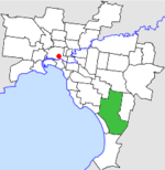
Springvale is a suburb in Melbourne, Victoria, Australia, 22 km (14 mi) south-east of Melbourne's Central Business District, located within the City of Greater Dandenong local government area. Springvale recorded a population of 22,174 at the 2021 census.Springvale is a large suburb occupying 11.2 km2 (4.3 sq mi), bounded by Westall Road to the west, Princes Highway and Police Road to the north, the Springvale Crematorium and Corrigan Road to the northeast, Heatherton Road to the south and Lawn Road to the southeast. Springvale is linked to the Melbourne CBD by Monash Freeway via the Ferntree Gully Road exit to the suburb's northwest.
Excerpt from the Wikipedia article Springvale, Victoria (License: CC BY-SA 3.0, Authors, Images).Springvale, Victoria
Springvale Road, Melbourne Springvale
Geographical coordinates (GPS) Address Nearby Places Show on map
Geographical coordinates (GPS)
| Latitude | Longitude |
|---|---|
| N -37.947 ° | E 145.153 ° |
Address
BP
Springvale Road 154-172
3171 Melbourne, Springvale
Victoria, Australia
Open on Google Maps


