place

Rodney Stoke

Civil parishes in SomersetMendip HillsVillages in Mendip District
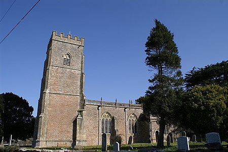
Rodney Stoke church
Rodney Stoke church

Rodney Stoke is a small village and civil parish, located at grid reference ST486501, 5 miles north-west of Wells, in the English county of Somerset. The village is on the A371 between Draycott and Westbury-sub-Mendip. The parish includes the larger village of Draycott. South of the A371 the parish includes an area of the Somerset Levels, extending to the River Axe. North of the A371 the southern slopes of the Mendip Hills rise to an area of the parish on the Mendip plateau. The parish is therefore an area of high biodiversity supporting local rare species of plants and animal life.

Excerpt from the Wikipedia article Rodney Stoke (License: CC BY-SA 3.0, Authors, Images).

Rodney Stoke
Scadden's Lane, Mendip

Geographical coordinates (GPS) Address Nearby Places
placeShow on map

Wikipedia: Rodney StokeContinue reading on Wikipedia

Geographical coordinates (GPS)

Latitude Longitude
N 51.2476 ° E -2.7357 °
placeShow on map

Address

Scadden's Lane

Scadden's Lane
BS27 3UR Mendip
England, United Kingdom
mapOpen on Google Maps

Rodney Stoke church
Rodney Stoke church
Share experience

Nearby Places

Rodney Stoke SSSI
Rodney Stoke SSSI

Rodney Stoke (grid reference ST492507) is a 69.6 hectare (172.0 acre) biological Site of Special Scientific Interest, just north of the village of Rodney Stoke in the Mendip Hills, Somerset, notified in 1957. Part of the site is a national nature reserve and part a Nature Conservation Review Woodland site. This site supports a mosaic of ancient semi-natural broadleaved woodland, scrub and species-rich unimproved grassland. Rodney Stoke occupies steep south west facing slopes of the Mendip Hills. The underlying rock types belong to the dolomitic conglomerate facies of the Triassic, and to the Carboniferous Limestone series. The latter are restricted to the woodlands Big Stoke and Little Stoke, which along with Calve's Plot Wood are ancient woodland sites. Big Stoke and Little Stoke were almost entirely clear-felled during World War I. Two nationally rare plants occur at Rodney Stoke: purple gromwell (Lithospermum purpurocaeruleum) and the endemic whitebeam (Sorbus anglica). The site supports a diverse fauna. Badgers (Meles meles) are common and two or three setts are occupied each year. Noctule bats (Nyctalus noctula) and pipistrelle bats (Pipistrellus pipistrellus) roost in Big Stoke. Breeding birds include buzzard (Buteo buteo) and spotted flycatcher (Muscicapa striata). Small enclosures and tall hedges provide sheltered conditions that are ideal for many species of invertebrate. Butterflies are well represented with marbled white (Melanargia galathea), purple hairstreak (Quercusia quercus), brown argus (Aricia agestis) and grayling (Hipparchia semele).

Draycott Sleights
Draycott Sleights

Draycott Sleights (grid reference ST483518) is a 61.95 hectares (153.1 acres) biological Site of Special Scientific Interest at Draycott in the Mendip Hills, Somerset, England, notified in 1987. The name is pronounced locally as "Slates", presumably a variation on the Saxon word Slade meaning amongst other things hillside, rather than in the same manner as the Yorkshire place of the same spelling. The Somerset Wildlife Trust reserve lies 3.5 km (2.2 mi) south east of Cheddar. It includes Draycott Sleights, 40.4 hectares (100 acres), and Draycott Housegrounds, 10.21 hectares (25.2 acres). Draycott Sleights is part of the Draycott Sleights Site of Special Scientific Interest (SSSI), Draycott Housegrounds is a County Wildlife Site. The entire reserve is within the Mendips Scarp Prime Biodiversity Area (PBA) and Mendip Hills Area of Outstanding Natural Beauty (AONB).Draycott Sleights supports extensive areas of traditionally managed species-rich unimproved calcareous grassland. Additional interest lies in a rich invertebrate fauna. The site is situated on steep south-west facing slopes of the Mendip Hills and ranges in altitude from 90 m (300 ft) to 270 m (890 ft). 165 species of flowering plant have been recorded. The varied topography together with the widespread scrub provide a number of locations with ideal conditions for invertebrates supporting a rich butterfly fauna typical of unimproved calcareous grassland. 32 species of resident breeding butterfly have been recorded. The occurrence of Adonis blue (Lysandra bellargus), silver-studded blue (Plebejus argus) and small blue (Cupido minimus) is of particular interest. Two nationally scarce species of fly, Symphoromyia immaculata and Bombylius canescens and one nationally scarce species of ant, Myrmica schencki have been recorded for this site.

Perch SSSI

The Perch (grid reference ST480532) is a 72.1 hectare (178.2 acre) biological Site of Special Scientific Interest close to Cheddar Gorge in the Mendip Hills, Somerset, England. It received SSSI notification in 1990. This site is important because it supports populations of nationally rare and scarce plants, together with grassland and woodland habitats which are nationally restricted in distribution.The site is located on the south side of the Mendip Hills occupying a position on a steep-sided ridge which runs north to south. The underlying rocks are almost entirely carboniferous limestone with a small amount of Triassic dolomitic conglomerate.The nationally rare purple gromwell (Lithospermum purpurocaeruleum) and the nationally scarce Ivy Broomrape (Orobanche hederae) also occur. Three species of orchid occur in these grassland areas: the Green-winged Orchid (Orchis morio), the pyramidal orchid (Anacamptis pyramidalis) and the Autumn Ladies'-tresses (Spiranthes spiralis). Two nationally rare plants, the Cheddar pink (Dianthus gratianopolitanus) and the Cheddar bedstraw (Galium fleurotii) are found on this site, as are two nationally scarce species: the rock stonecrop (Sedum forsterianum) and the spring cinquefoil (Potentilla tabernaemontani).This variety of habitats ensures that a wide range of fauna occurs on the site. In total 22 species of mammal have been recorded including a strong population of dormouse (Muscardinus avellanarius) and five species of bat, including the Greater Horseshoe bat (Rhinolophus ferrumequinum) and Lesser Horseshoe bat (Rhinolophus hipposideros) which use the site for feeding. One small roost of lesser horseshoe bats is known. Both species of horseshoe bat are nationally rare. Thirty species of birds are known to breed within this site and at least 23 species of butterfly breed here.

Brimble Pit and Cross Swallet Basins

Brimble Pit and Cross Swallet Basins (grid reference ST512505) is a 154.3 hectare (381.3 acre) geological Site of Special Scientific Interest between Wookey Hole and Priddy in the Mendip Hills, Somerset, notified in 1987. The site covers the two adjacent karstic basins draining into Brimble Pit and Cross Swallet. These are the two best defined of the belt of large shallow closed depressions which account for the total Topography along the southern edge of the Mendip Hills. The Brimble Pit depression has a large old lake sediment floor now pitted with sinkholes, while the Cross Swallet Basin feeds to a single active sinkhole around which are well preserved terraces of both rock and sediment. Both depressions have marginal cols feeding to overflow channels now permanently dry. The site also contains important Pleistocene/Quaternary mammal remains within sediments infilling former caverns exposed on the north east face of Westbury Quarry.The swallet was excavated by William Stanton between 1991 & 1992 for spelaeological purposes. However, archaeological material was discovered, leading Stanton to separate the deposits he was removing and examine them for archaeological material, which included 42 sherds of Grooved Ware pottery and a polished greenstone axehead.The area is included in the Cook's Fields Nature Reserve run by the Somerset Wildlife Trust.The Site of Special Scientific Interest is divided into units by Natural England. The Church Commissioners own the land on which part of unit 1 is situated