Fort of São Bruno

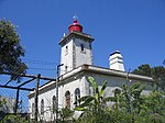
The Fort of São Bruno is situated on the estuary of the River Tagus in Caxias, Oeiras municipality, near Lisbon in Portugal. It was built in 1647 and became operational in 1649 as part of the construction of a line of forts to control access to Lisbon, which stretched from Cabo da Roca on the Atlantic coast to the Belém Tower near Lisbon. The fort is well preserved, following its original design, and is considered one of the most attractive examples of maritime military architecture on the Portuguese coast. It presently serves as the headquarters of the Associação Portuguesa dos Amigos dos Castelos (Portuguese association of friends of castles).
Excerpt from the Wikipedia article Fort of São Bruno (License: CC BY-SA 3.0, Authors, Images).Fort of São Bruno
Passeio Marítimo Caxias - Cruz Quebrada, Oeiras e São Julião da Barra, Paço de Arcos e Caxias
Geographical coordinates (GPS) Address External links Nearby Places Show on map
Geographical coordinates (GPS)
| Latitude | Longitude |
|---|---|
| N 38.6979253 ° | E -9.2748499 ° |
Address
Forte de São Bruno (Forte de São Bruno de Caxias)
Passeio Marítimo Caxias - Cruz Quebrada
2760-064 Oeiras e São Julião da Barra, Paço de Arcos e Caxias
Portugal
Open on Google Maps


