place

St Mary's, High Church

Church of England church buildings in NorthumberlandMorpeth, NorthumberlandUnited Kingdom Anglican church building stubsUse British English from May 2019
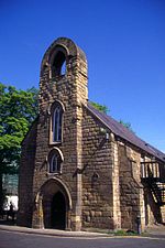
The Church of St Mary the Virgin, Morpeth geograph.org.uk 613740

St Mary's, also known as St Mary the Virgin, is an ancient Grade I listed Church of England parish church located in Morpeth, Northumberland. The church is to the south of the River Wansbeck in Morpeth, which is an area known as High Church. The oldest remaining parts of the structure belong to the Transitional Early English style of the mid to late 12th century, but the church is mostly in the 14th century style. The church, which was the main Anglican place of worship in the area until the 1840s, has been restored several times after being destroyed by the Scandinavians, Scottish and Cromwellians in the 10th and later centuries.The grave of Emily Wilding Davison, a suffragette who was killed when she fell under the King's horse during The Derby in 1913, lies in St Mary's graveyard. Her gravestone bears the slogan of the Women's Social and Political Union: "Deeds not words".

Excerpt from the Wikipedia article St Mary's, High Church (License: CC BY-SA 3.0, Authors, Images).

St Mary's, High Church
St Mary's Field,

Geographical coordinates (GPS) Address External links Nearby Places
placeShow on map

Wikipedia: St Mary's, High ChurchContinue reading on Wikipedia

Geographical coordinates (GPS)

Latitude Longitude
N 55.159722222222 ° E -1.6922222222222 °
placeShow on map

Address

St Mary the Virgin Church

St Mary's Field
NE61 2QF , Loansdean
England, United Kingdom
mapOpen on Google Maps

linkWikiData (Q17527477)
linkOpenStreetMap (142174708)

The Church of St Mary the Virgin, Morpeth geograph.org.uk 613740
Share experience

Nearby Places

Morpeth, Northumberland

Morpeth is a historic market town in Northumberland, England, lying on the River Wansbeck. Nearby towns include Ashington and Bedlington. In the 2011 census, the population of Morpeth was given as 14,017, up from 13,833 in the 2001 census. The earliest evidence of settlement is believed to be from the Neolithic period, and some Roman artifacts have also been found. The first written mention of the town is from 1080, when the de Merlay family was granted the barony of Morpeth. The meaning of the town's name is uncertain, but it may refer to its position on the road to Scotland and a murder which occurred on that road. The de Merlay family built two castles in the town in the late 11th century and the 13th century. The town was granted its coat of arms in 1552. By the mid-1700s it had become one of the main markets in England, having been granted a market charter in 1200, but the opening of the railways in the 1800s led the market to decline. The town's history is celebrated in the annual Northumbrian Gathering. Morpeth is governed by Northumberland County Council and Morpeth Town Council. The town is split into three wards – North, Kirkhill and Stobhill – for the purposes of parish elections. In 2008 the town suffered a severe flood, which was repeated in 2012, resulting in the construction of new flood defences. Morpeth railway station is on the east coast line and a curve to the south of it has caused several rail crashes. Several sports teams compete in Morpeth, with Morpeth Town A.F.C. having been the winner of the FA Vase in 2016. The town hosted its own Olympics from 1873 to 1958. Two middle schools, a high school and seven first schools are situated in Morpeth, as well as several churches of Anglican, Roman Catholic, United Reformed and Methodist denominations. Morpeth's Carlisle Park, the recipient of several awards, contains one of the four floral clocks in England.