place

Monteath Mausoleum

Buildings and structures completed in 1864JedburghMausoleums in Scotland
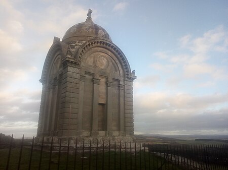
Monteath Mausoleum 2018 view

The Monteath Mausoleum is a large landmark in the Scottish Borders near the village of Ancrum. The listed building can be seen from the A68 road just north of Jedburgh. It was built in 1864 and renovated in 2018.

Excerpt from the Wikipedia article Monteath Mausoleum (License: CC BY-SA 3.0, Authors, Images).

Geographical coordinates (GPS)

Latitude Longitude
N 55.533635 ° E -2.61517 °
placeShow on map

Address

Monteath Mausoleum

A68
TD6 9EU
Scotland, United Kingdom
mapOpen on Google Maps

linkWikiData (Q17845440)
linkOpenStreetMap (187703368)

Monteath Mausoleum 2018 view
Share experience

Nearby Places

Ancrum
Ancrum

Ancrum (Scottish Gaelic: Alan Crom) is a village in the Borders area of Scotland, 5 km (3.1 mi) northwest of Jedburgh. The village — which currently has a population of around 300 — is situated just off the A68 trunk road on the B6400, which runs through Ancrum. Lilliesleaf lies 7 miles (11 km) further along the B6400 and Denholm can be reached along the unclassified road which runs parallel to the River Teviot. The name of this place, anciently Alne-crumb, is derived from the situation of its village on a bend of the River Alne, now the Ale. There were formerly two villages distinguished by the appellations of Over Ancrum and Nether Ancrum, of the former of which nothing now remains. The principal event of historical importance is the Battle of Ancrum Moor, which originated in an attempt made in 1545, by Ralph Evers and Bryan Layton, to possess themselves of the lands of the Merse and Teviotdale, which had been conferred upon them by a grant of Henry VIII, king of England. Archibald Douglas, 6th Earl of Angus, who had considerable property in that district, determined to resist the attempt, and a battle between his forces and those of the English took place on a moor about a mile and a half north of the village, in which the latter were defeated with great loss. In this conflict, both the villages of Ancrum were burnt to the ground; the village of Nether Ancrum was soon afterwards rebuilt, but of the other nothing remains but the ruins of one or two dilapidated houses.
Mertoun
Mertoun

Mertoun is a parish in the south-west of the historic county of Berwickshire in the Scottish Borders area of Scotland. Together with the parish of Maxton, Roxburghshire it forms the Maxton and Mertoun Community Council area. It was included in the former Ettrick and Lauderdale District of Borders Region, by the Local Government (Scotland) Act 1973, from 1975 to 1996. The parish is bounded by the Berwickshire parish of Earlston to the north and by the Roxburghshire parishes of Smailholm and Makerstoun to the east, Maxton and St Boswells on the south and Melrose in the west. Maxton, St. Boswell's and Melrose lie on the other side of the River Tweed, which forms the southern and western border of the parish.The parish includes the hamlets of Dryburgh and Clintmains, the historically important sites of Dryburgh Abbey, Mertoun House, Mertoun Bridge and Bemersyde House. Also the statue of William Wallace at Bemersyde. Mertoun Church was erected in 1658 and restored in 1820 and 1898. It stands in a wood near Mertoun House ½ mile south-east of Clintmains. The date 1658 is carved in stone above one of the doors. For church purposes the parish is united with Maxton and linked with St Boswells and Newtown St Boswells.The original church of 1241, not on the same site, was dedicated to St Ninian. Robert Haig of Bemersyde built himself a stall or "laird's loft" in the old church in 1594. His neighbours, the Kers of Shaws and Dalcowie, took offence and dismantled it. A Parochial Board was established under the Poor Law (Scotland) Act 1845. With the Local Government (Scotland) Act 1894 the Parish Council was established. Civil parishes in Scotland, as units of local government, were abolished in 1929 but have been used later for census and other purposes. The civil parish has an area of 6377 acres and a population of 309 (in 2011).