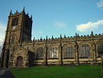
Gwernymynydd
Communities in FlintshireVillages in Flintshire

Gwernymynydd (Welsh for 'Alder trees on the mountain') is a village outside the market town of Mold in Flintshire, Wales. It forms part of the Gwernymynydd and Cadole (sometimes shortened to Gwernymynydd) community. At its highest point it is 1000 feet above sea level. It has two pubs (The Swan and The Owain Glyndwr) and a once-busy garage, now a coach depot, home to Eagles & Crawford. Gwernymynydd is also home to a farm, a community centre, and a village primary school. Neighbouring communities include Gwernaffield, Llanferres, Nercwys, and Mold. The population at the 2011 census was 1,141.
Excerpt from the Wikipedia article Gwernymynydd (License: CC BY-SA 3.0, Authors, Images).Gwernymynydd
Ruthin Road,
Geographical coordinates (GPS) Address Nearby Places Show on map
Geographical coordinates (GPS)
| Latitude | Longitude |
|---|---|
| N 53.155 ° | E -3.171 ° |
Address
Ruthin Road
Ruthin Road
CH7 4AR , Gwernymynydd
Wales, United Kingdom
Open on Google Maps


