place

Highlands, Holyoke, Massachusetts
Geography of Hampden County, MassachusettsHampden County, Massachusetts geography stubsNeighborhoods in Holyoke, MassachusettsStreetcar suburbs
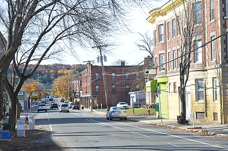
Highlands Center, Holyoke, Massachusetts

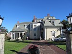
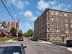
The Highlands is a neighborhood in Holyoke, Massachusetts located northwest of the city center, adjacent to the downtown. Originally a series of farms and estates, it was first known as Manchester Grounds, as the area's land was reportedly purchased by a company of landowners from Manchester, New Hampshire soon after Holyoke was first chartered, in 1852. However while this name persisted for much of the 19th century, these holders would default on their estates by 1856. The area was further divided into new building lots in the 1870s and saw considerable development as a streetcar suburb when the Holyoke Street Railway completed an extension to the area in 1886. Another early name for the section between Lincoln and Hampden streets was Money Hole Hill, a name also used by Mary Doyle Curran in her portrayal of the neighborhood in her novel The Parish and the Hill. By 1897 the neighborhood had been christened its present name for its higher elevation at the foot of the Mount Tom Range. Today the neighborhood contains many historic Victorian houses and about 400 acres (160 ha) of predominantly residential zoning with some commercial development, as well as the Kennedy and Morgan Street Parks.

Excerpt from the Wikipedia article Highlands, Holyoke, Massachusetts (License: CC BY-SA 3.0, Authors, Images).

Highlands, Holyoke, Massachusetts
Lexington Avenue, Holyoke

Geographical coordinates (GPS) Address Nearby Places
placeShow on map

Wikipedia: Highlands, Holyoke, MassachusettsContinue reading on Wikipedia

Geographical coordinates (GPS)

Latitude Longitude
N 42.219444444444 ° E -72.624444444444 °
placeShow on map

Address

Lexington Avenue 10
01040 Holyoke
Massachusetts, United States
mapOpen on Google Maps

Highlands Center, Holyoke, Massachusetts
Share experience

Nearby Places

Log Pond Cove
Log Pond Cove

Log Pond Cove, previously known as Money Hole, is a former log pond and scenic wayside on the Connecticut River, about half a mile upstream from the Holyoke Dam at South Hadley Falls. The 18.5-acre (75,000 m2) pond was once used for ice cutting, as well as log drives from points north, diverted there in the late 19th and early 20th century. The log boom once set up there supplied contractors and the paper mills of Holyoke's industrial economy. After the last of these logging drives in 1915, silt gradually began to fill in the cove, gradually changing its river island border into a peninsula. By the mid-20th century the water body and its immediate surroundings had been acquired by the Holyoke Water Power Company, and in 1987 the site was briefly considered for use as the site of a children's nature camp. In 1998 it was recorded as the first body of water in the Connecticut River watershed to become infested with water chestnut, an invasive species that, despite efforts by Federal and local authorities, has persisted since that time. The area was acquired by Holyoke Gas & Electric as part of the dam and canal network on December 14, 2001, and is presently managed in part by US Fish and Wildlife Service staff and volunteers as an extension of the Silvio O. Conte National Fish and Wildlife Refuge. Today the cove is surrounded by 62 acres of undeveloped wetlands and functions as a sanctuary to many bird species, including great blue herons and several duck species.

South Hadley Canal
South Hadley Canal

The South Hadley Canal was a canal along the Connecticut River in South Hadley, Massachusetts. It was the earliest navigable canal in the United States, with operation commencing in 1795. It has been listed on the National Register of Historic Places as the South Hadley Canal Historic District. The canal dates to February 1792, when leading citizens of western Massachusetts proposed to build a canal around the Great Falls at South Hadley, a 53-foot (16 m) drop in the Connecticut River that blocked boat transport. At that time, all cargo needed to be unloaded for 2.5 miles (4.0 km) of land transport around the falls, driving river transport cost for a bushel of wheat from Northampton, Massachusetts to Windsor, Connecticut to more than double its transport costs by sea from Hartford to Boston. John Hancock, then Governor of Massachusetts, signed the charter which incorporated the Proprietors of the Locks and Canals on the Connecticut River. Their corporate seal bore the motto "SIC TRANSIT - Public & Private Good". Funds were raised both locally and internationally, with four Dutch investment houses owning slightly over 50% of the stock. The canal was built by some 240 local workers. In April 1795 it opened to commercial traffic. (Nearby Turners Falls Canal opened three years later.) First year revenue came to $3,109 at 75 cents per ton. By 1816 tolls had grown to over $16,000. In 1826 the Barnet, the first steamboat to operate on the Connecticut River, passed through the South Hadley Canal on its way to Vermont. However, by 1843 competing railroads had begun to erode income, and the canal closed as uneconomical in 1862. Rather than use locks, the canal was built with an unusual "inclined plane" to transport 20-foot (6.1 m) by 60-foot (18 m) flatboats over the falls. The inclined plane appears to have been pioneered on England's Ketley Canal in 1788. This was its first use in American canals, and served as a pattern for others including the Morris Canal in New Jersey. On the South Hadley Canal's inclined plane, the boat was first maneuvered into a special cart, then hauled up or down a ramp built of solid stone, 275 feet (84 m) long by 30 feet (9.1 m) wide, covered with strong wood planks, and having a slope of 13.5 degrees. Lifting power was supplied by two overshot waterwheels 16 feet (4.9 m) in diameter, one on each side of the inclined plane, connected to the cart with chains. The cart had unequal wheel sizes to keep the boat level during transport. Total transport time was about 15 minutes. In 1805, after about 10 years of use, however, the inclined plane was replaced by a series of five locks when it was necessary to deepen the canal. Today The Bicentennial Canal Park serves as a historic memorial, preserving the historical remnants of the canal. The overlook deck provides vistas of the Mount Tom Range and the Connecticut River. Holyoke Gas & Electric maintains Texon Park, Lower Riverside Park, and Gatehouse Park along the Holyoke dam. Lower Riverside Park overlooks the site of the former inclined plane and lock system, remnants of which are still visible today.

Holyoke, Massachusetts

Holyoke is a city in Hampden County, Massachusetts, United States, that lies between the western bank of the Connecticut River and the Mount Tom Range. As of the 2020 census, the city had a population of 38,238. Located 8 miles (13 km) north of Springfield, Holyoke is part of the Springfield Metropolitan Area, one of the two distinct metropolitan areas in Massachusetts. Holyoke is among the early planned industrial cities in the United States. Built in tandem with the Holyoke Dam to utilize the water power of Hadley Falls, it is one of a handful of cities in New England built on the grid plan. During the late 19th century the city produced an estimated 80% of the writing paper used in the United States and was home to the largest paper mill architectural firm in the country, as well as the largest paper, silk, and alpaca wool mills in the world. Although a considerably smaller number of businesses in Holyoke work in the paper industry today, it is still commonly referred to as "The Paper City". Today the city contains a number of specialty manufacturing companies, as well as the Massachusetts Green High Performance Computing Center, an intercollegiate research facility which opened in 2012. Holyoke is also home to the Volleyball Hall of Fame and known as the "Birthplace of Volleyball", as the internationally played Olympic sport was invented and first played at the local YMCA chapter by William G. Morgan in 1895.While managing the Holyoke Testing Flume in the 1880s, hydraulic engineer Clemens Herschel invented the Venturi meter to determine the water use of individual mills in the Holyoke Canal System. This device, the first accurate means of measuring large-scale flows, is widely used in a number of engineering applications today, including waterworks and carburators, as well as aviation instrumentation. Powered by these municipally owned canals, Holyoke has among the lowest energy rates in the Commonwealth, and as of 2016 between 85% and 90% of the city's energy was carbon neutral, with administrative goals in place to reach 100% in the future.