place

Burledge Hill

Bath and North East SomersetEngvarB from September 2013Environment of SomersetHill forts in SomersetHills of Somerset
History of SomersetIron Age sites in SomersetMeadows in SomersetMendip HillsNeutral grassland Sites of Special Scientific InterestScheduled monuments in Bath and North East SomersetSites of Special Scientific Interest in AvonSites of Special Scientific Interest notified in 2005
Bishop Sutton
Bishop Sutton

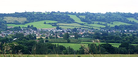
Burledge Hill (grid reference ST588587) is on the southern edge of the village of Bishop Sutton, Somerset, England. It is the site of a Site of Special Scientific Interest and an univallate Iron Age hillfort.

Excerpt from the Wikipedia article Burledge Hill (License: CC BY-SA 3.0, Authors, Images).

Burledge Hill
Sutton Hill Road,

Geographical coordinates (GPS) Address Nearby Places
placeShow on map

Wikipedia: Burledge HillContinue reading on Wikipedia

Geographical coordinates (GPS)

Latitude Longitude
N 51.3259 ° E -2.59267 °
placeShow on map

Address

Sutton Hill Road

Sutton Hill Road
BS39 5UN , Stowey-Sutton
England, United Kingdom
mapOpen on Google Maps

Bishop Sutton
Bishop Sutton
Share experience

Nearby Places

Church of St Nicholas and the Blessed Virgin Mary, Stowey

The Anglican Parish Church of St Nicholas and the Blessed Virgin Mary at Stowey within the English county of Somerset dates from the 13th century. It is a Grade II listed building.There may have been a wooden church on the site at the time of the Domesday book, although the first written record from the Bath cartulary is of 1235. The oldest part of the current stone church is the chancel at the eastern end, which now contains the altar and has a small priest's door, above which is a small carved figure. The nave was added in the 14th century. The three-stage tower, which was added in the 14th or early 15th century, is supported by diagonal buttresses and has a stair turret in the northeast corner. It has six bells which are regularly rung for services. Five of the bells are from the local foundry of the Bilbie family, to which a sixth from the Whitechapel Bell Foundry was added in 1991. The church, which is adjacent to Stowey House, is built of the same local red sandstone, with alternating lias and red sandstone bands to the nave. It has a tiled roof above the chancel, while the nave and north porch have a slate roof. The church was altered in the 17th century, and in the 19th it underwent a Victorian restoration that included replacement of part of the roof and removal of the double-decker pulpit and a gallery. Inside the church are wall paintings by Henry Strachey from the early 20th century. There are life-sized representations of St Nicholas and St Mary on either side of the altar. Also in the chancel are paintings of the miraculous Feeding the multitude and of disciples on the road to Emmaus. The Last Judgment is pictured over the chancel arch with an equal number of angels of light and darkness.There are also wall monuments from the mid-18th century by Thomas Paty and other sculptors, commemorating the Jones and Sandford families. The font is from the 14th century. The organ was installed in the 1930s and electrified when electricity was brought into the church in 1965. Above the entrance door is a funerary hatchment which was made to celebrate the restoration of Charles II in 1660.During the 16th or 17th century, the parish was a chapelry of Chew Magna. The parish is now part of the benefice of Clutton with Cameley, Bishop Sutton and Stowey within the archdeaconry of Bath.

Chew Valley

The Chew Valley is an affluent area in North Somerset, England, named after the River Chew, which rises at Chewton Mendip, and joins the River Avon at Keynsham. Technically, the area of the valley is bounded by the water catchment area of the Chew and its tributaries; however, the name Chew Valley is often used less formally to cover other nearby areas, for example, Blagdon Lake and its environs, which by a stricter definition are part of the Yeo Valley. The valley is an area of rich arable and dairy farmland, interspersed with a number of villages. The landscape consists of the valley of the River Chew and is generally low-lying and undulating. It is bounded by higher ground ranging from Dundry Down to the north, the Lulsgate Plateau to the west, the Mendip Hills to the south and the Hinton Blewett, Temple Cloud, Clutton and Marksbury plateau areas to the east. The valley's boundary generally follows the top of scarp slopes except at the southwestern and southeastern boundaries where flat upper areas of the Chew Valley grade gently into the Yeo Valley and eastern Mendip Hills respectively. The River Chew was dammed in the 1950s to create Chew Valley Lake, which provides drinking water for the nearby city of Bristol and surrounding areas. The lake is a prominent landscape feature of the valley, a focus for recreation, and is internationally recognised for its nature conservation interest, because of the bird species, plants and insects. The area falls into the domains of councils including Bath and North East Somerset, North Somerset and Mendip. Part of the area falls within the Mendip Hills Area of Outstanding Natural Beauty. Most of the undeveloped area is within the Bristol/Bath Green Belt. Many of the villages date back to the time of the Domesday Book and there is evidence of human occupation since the Stone Age. There are hundreds of listed buildings with the churches being Grade I listed. The main commercial centre is Chew Magna.