place

Deep Lake (Thurston County, Washington)

Lakes of Thurston County, WashingtonLakes of Washington (state)
Millersylvania State Park 13

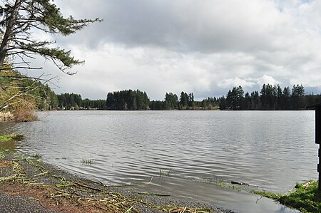
Deep Lake is a 66-acre (27 ha) body of water lying eight miles (13 km) south of Olympia in Thurston County, Washington. It is 17 feet (5.2 m) deep at its deepest point and has a water volume of 771 acre-feet (951,000 m3). The lake drains into Black River by way of Beaver Creek and Scott Lake. Deep Lake is located in Section 3, Township 16N, Range 2W, Willamette. The lake is bordered on two sides by Millersylvania State Park. An RV resort camp occupies the lake's eastern shore. The lake's fish population includes stocked rainbow trout and naturally reproducing largemouth bass, bluegill, yellow perch, and pumpkinseed.

Excerpt from the Wikipedia article Deep Lake (Thurston County, Washington) (License: CC BY-SA 3.0, Authors, Images).

Deep Lake (Thurston County, Washington)
Millersylvania State Park,

Geographical coordinates (GPS) Address Nearby Places
placeShow on map

Wikipedia: Deep Lake (Thurston County, Washington)Continue reading on Wikipedia

Geographical coordinates (GPS)

Latitude Longitude
N 46.9074104 ° E -122.9124988 °
placeShow on map

Address

Millersylvania State Park

Washington, United States
mapOpen on Google Maps

Millersylvania State Park 13
Share experience

Nearby Places

Rocky Prairie
Rocky Prairie

Rocky Prairie is a Puget prairie that is about 56 miles (90 km) southwest of Seattle, Washington, United States, and about 10 miles (16 km) south of Washington's capital city of Olympia. It sits very close to the Millersylvania State Park, the community of Maytown, and the city of Tenino. Old Highway 99 runs through Rocky Prairie. The part of the prairie west of the highway is called West Rocky Prairie. Both the west and east sides of the prairie have various plant and animal species. Many of the plant species are flowering plants. Both sides also have areas of Mima mounds (not to be confused with the Mima mounds at Mima Mounds Natural Area Preserve about 10.5 kilometers or 6.5 miles to the west). Rocky Prairie is divided into several different properties. The two land owners west of Old Highway 99 are the Washington State Department of Fish and Wildlife and the Port of Tacoma. A major land owner east of Old Highway 99 is the Washington State Department of Natural Resources. There is also another property on the east side owned by Thurston County which has a gravel pit located on it. Some of the prairie on the east side is private property, and has pastures and houses on it. In West Rocky Prairie, the property that belongs to the Washington State Department of Fish and Wildlife is called the West Rocky Prairie Wildlife Area. The size of the property is 810 acres (330 hectares). Part of the property is wooded, and part of it is in the prairie. The West Rocky Prairie Unit has over 300 acres (120 hectares) of woods, 360 acres (150 hectares) of wetlands, 40 acres (16 hectares) of Quercus garryana (Garry oak trees), and 300 acres (120 hectares) of Mima mounds.