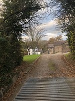
The Cwm, Llantrisant, Monmouthshire
Country houses in MonmouthshireGrade II* listed buildings in MonmouthshireGrade II* listed houses

The Cwm, Llantrisant, Monmouthshire is a farmhouse dating from the 16th century. Expanded in both the 17th and 18th centuries, The Cwm is a Grade II* listed building, its listing describing it as "a substantial farmhouse of distinctive T-plan".
Excerpt from the Wikipedia article The Cwm, Llantrisant, Monmouthshire (License: CC BY-SA 3.0, Authors, Images).The Cwm, Llantrisant, Monmouthshire
Geographical coordinates (GPS) Address Nearby Places Show on map
Geographical coordinates (GPS)
| Latitude | Longitude |
|---|---|
| N 51.6703 ° | E -2.8756 ° |
Address
NP15 1LE , Llantrisant Fawr
Wales, United Kingdom
Open on Google Maps


