Mount Madonna
Gilroy, CaliforniaMountains of Northern CaliforniaMountains of Santa Clara County, CaliforniaMountains of the San Francisco Bay AreaSanta Clara County, California geography stubs

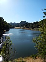
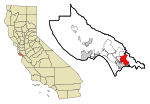
Mount Madonna is a prominent peak located near the southern end of the Santa Cruz Mountains in southwest Santa Clara County, California. The iconic landmark is surrounded by a county park, and is viewable along U.S. Route 101 in South Santa Clara Valley, and California State Route 152 near Watsonville in south Santa Cruz County.
Excerpt from the Wikipedia article Mount Madonna (License: CC BY-SA 3.0, Authors, Images).Mount Madonna
Lower Miller Trail,
Geographical coordinates (GPS) Address Nearby Places Show on map
Geographical coordinates (GPS)
| Latitude | Longitude |
|---|---|
| N 37.0121721 ° | E -121.7049481 ° |
Address
Lower Miller Trail
California, United States
Open on Google Maps


