Enspijk
Gelderland geography stubsPopulated places in GelderlandWest Betuwe

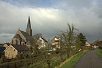
Enspijk is a village in the Dutch province of Gelderland. It is a part of the municipality of West Betuwe, and lies about 14km (8.69 miles) west of Tiel. Enspijk was first mentioned in 1148 as Inspic, and means promontory. The en (inwards) was added to distinguish from neighbouring Spijk. Enspijk developed as a concentrated esdorp perpendicular to the dike of the Linge. The Dutch Reformed Church dates from the early 15th century and is a replacement of a 13th century church. The tower was built at the end of the 15th century. Huis te Enspijk was a castle. It was probably built in the 15th century, and was demolished in 1828. In 1840, it was home to 247 people.
Excerpt from the Wikipedia article Enspijk (License: CC BY-SA 3.0, Authors, Images).Enspijk
Beemd, West Betuwe
Geographical coordinates (GPS) Address Nearby Places Show on map
Geographical coordinates (GPS)
| Latitude | Longitude |
|---|---|
| N 51.883611111111 ° | E 5.2130555555556 ° |
Address
Monument
Beemd
4157 GE West Betuwe
Gelderland, Netherlands
Open on Google Maps


