Limbongan, Brunei
Brunei geography stubsVillages in Brunei-Muara District

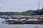
Limbongan was a neighbourhood in Kampong Ayer, the riverine stilt settlement in Bandar Seri Begawan, the capital of Brunei. It was officially a village subdivision under Tamoi, a mukim (subdistrict) of Brunei-Muara District, and had the postcode BL1312. Limbongan was one of the traditional stilt neighbourhoods which had existed along the banks of the Kedayan River, a tributary of the Brunei River in the vicinity of Kampong Ayer, before they were eventually demolished in the 2010s and redeveloped into Taman Mahkota Jubli Emas, a riverfront park.
Excerpt from the Wikipedia article Limbongan, Brunei (License: CC BY-SA 3.0, Authors, Images).Limbongan, Brunei
Sultan Omar 'Ali Saifuddien Pedestrian Bridge,
Geographical coordinates (GPS) Address Nearby Places Show on map
 Continue reading on Wikipedia
 Geographical coordinates (GPS)
| Latitude | Longitude |
|---|---|
| N 4.887889 ° | E 114.935711 ° |
Address
Jambatan Pejalan Kaki Sultan Omar 'Ali Saifuddien
Sultan Omar 'Ali Saifuddien Pedestrian Bridge
BS8511 , Sungai Kedayan A
Brunei
Open on Google Maps