place

Ravenswaaij

BurenGelderland geography stubsPopulated places in Gelderland
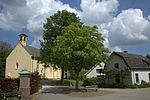
Ravenswaaijsesteeg in Ravenswaaij. in de Betuwe

Ravenswaaij is a village in the Dutch province of Gelderland. It is a part of the municipality of Buren, and lies about 10 km northwest of Tiel. It was first mentioned in 1139 as Raueneswade, and means "fordable place of Raven (person)". Ravenswaaij started along the Lek River. A linear settlement appeared on the river dike. The church was destroyed in 1573 by the Spanish troops. The current church dates from 1644. In 1840, it was home to 368 people.

Excerpt from the Wikipedia article Ravenswaaij (License: CC BY-SA 3.0, Authors, Images).

Ravenswaaij
Engweg, Buren

Geographical coordinates (GPS) Address Nearby Places
placeShow on map

Wikipedia: RavenswaaijContinue reading on Wikipedia

Geographical coordinates (GPS)

Latitude Longitude
N 51.95 ° E 5.3333333333333 °
placeShow on map

Address

Engweg 1
4119 LV Buren
Gelderland, Netherlands
mapOpen on Google Maps

Ravenswaaijsesteeg in Ravenswaaij. in de Betuwe
Share experience

Nearby Places

Lower Rhine
Lower Rhine

The Lower Rhine (German: Niederrhein, pronounced [ˈniːdɐˌʁaɪ̯n] (listen); kilometres 660 to 1,033 of the river Rhine) flows from Bonn, Germany, to the North Sea at Hook of Holland, Netherlands (including the Nederrijn or "Nether Rhine" within the Rhine–Meuse–Scheldt delta); alternatively, Lower Rhine may refer to the part upstream of Pannerdens Kop, excluding the Nederrijn. Almost immediately after entering the Netherlands, the Rhine splits into numerous branches. The main branch is called the Waal which flows from Nijmegen to meet the Meuse; after which it is called Merwede. Near Rotterdam the river is known as Nieuwe Maas, and becomes the Nieuwe Waterweg flowing into the North Sea at Hook of Holland. The downstream Lower Rhine is a low lying land. Up to the beginning of industrialization roughly one fifth of the land area could only be used as pasture: an endless meadow, which could not be farmed because of flooding and a high ground-water level. However, the remaining soils of the Lower Rhine were always very fertile. That can also be seen in the farmsteads. The houses are relatively large, with the intention of accommodating a plentiful harvest and many cattle. The Nederrijn refers to the more northern former main branch of the Rhine, which flows past Arnhem; splits off the IJssel which flows into the IJsselmeer and then splits into the Lek and the Kromme Rijn at Wijk bij Duurstede. The Lek flows into the Merwede. The Kromme Rijn continues past Utrecht, becomes the Leidse Rijn, then Oude Rijn and flows into the North Sea at Katwijk. There are other minor branches such as the Vecht, Hollandse IJssel and the Noord. The German term Niederrhein refers both to the German section of the Lower Rhine as well as to parts of the surrounding Lower Rhine region.

Nederrijn
Nederrijn

Nederrijn (Dutch pronunciation: [ˈneːdəˌrɛin]; "Lower Rhine"; distinct from the Lower Rhine or Niederrhein further upstream) is the Dutch part of the Rhine from the confluence at the town of Angeren of the cut-off Rhine bend of Oude Rijn (Gelderland) and the Pannerdens Kanaal (which was dug to form the new connection between the Waal and Nederrijn branches). The city of Arnhem lies on the right (north) bank of the Nederrijn, just past the point where the IJssel branches off. The Nederrijn flows on to the city of Wijk bij Duurstede, from where it continues as the Lek. The once-important but now small Kromme Rijn branch (in Roman times part of the Limes Germanicus and border river of the Roman Empire) carries the name "Rhine" towards the city of Utrecht. From the city of Utrecht Kromme Rijn forks into the Vecht to the north, and into the Oude Rijn (Utrecht and South Holland) to the west. The first part is channelised and known as Leidse Rijn (Leiden Rhine), after the railway bridge near Harmelen (municipality Woerden) it's known as Oude Rijn, flowing westward to the North Sea. In order to regulate the distribution of drainage between the different branches of the Rhine, several dams have been constructed. If the dams are closed, there is little flow in the Nederrijn and most of the water is drained by the IJssel. As for the Old Rhine, close to the North Sea a pumping station prevents the river for sea tides and silting. Bridges over the Nederrijn are in Arnhem (railway and three road bridges), in Heteren (A50) and Rhenen. Ferries are found near Doorwerth, Wageningen, Opheusden, Elst and Amerongen.