place

Memorial Blood Centers
1946 establishments in MinnesotaBlood banks in the United StatesMedical and health organizations based in MinnesotaOrganizations based in Saint Paul, MinnesotaOrganizations established in 1946
Memorial Blood Centers

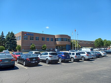
Memorial Blood Centers is a blood bank in Minnesota, United States. It is a division of Innovative Blood Resources (IBR), and supplies blood to hospitals and clinic partners, national blood centers, biotechnology companies, research institutions, in the US and abroad. The blood bank is a member of America's Blood Centers, the Minnesota Hospital Association (MHA), American Association of Blood Banks (AABB), and Blood Centers of America. It is not affiliated with the American Red Cross. IBR was formed in 2010 as a merger of Memorial Blood Centers and Nebraska Community Blood Bank to mitigate the increasing costs of blood collection and testing. It formed a strategic partnership with New York Blood Center (NYBC) in 2016 to give them access to blood donors in the Midwestern United States.

Excerpt from the Wikipedia article Memorial Blood Centers (License: CC BY-SA 3.0, Authors, Images).

Memorial Blood Centers
Pelham Boulevard, Saint Paul Saint Anthony Park

Geographical coordinates (GPS) Address External links Nearby Places
placeShow on map

Wikipedia: Memorial Blood CentersContinue reading on Wikipedia

Geographical coordinates (GPS)

Latitude Longitude
N 44.963611111111 ° E -93.201111111111 °
placeShow on map

Address

Memorial Blood Centers

Pelham Boulevard 737
55104 Saint Paul, Saint Anthony Park
Minnesota, United States
mapOpen on Google Maps

linkWikiData (Q30290600)
linkOpenStreetMap (62022126)

Memorial Blood Centers
Share experience

Nearby Places

Center for Victims of Torture

The Center for Victims of Torture (CVT) is an international non-profit headquartered in St. Paul, Minnesota that provides direct care for those who have been tortured, trains partner organizations in the United States and around the world who can prevent and treat torture, conducts research to understand how best to heal survivors, and advocates for an end to torture. CVT's mission is to heal the wounds of torture on individuals, their families and their communities, and to end torture worldwide and it has won the APA International Humanitarian Award from the American Psychological Association Since its founding in 1985, CVT has: Rehabilitated over 30,000 survivors through direct healing. Engaged in post-conflict community building after some of the world's deadliest wars, working in Guinea, Sierra Leone, Liberia, Democratic Republic of Congo, Jordan and Kenya. Pioneered research in torture survivor rehabilitation to better understand the effects of torture and how best to heal survivors. Led efforts to end the practice of torture by the US government, including President Obama's executive order banning torture and cruel treatment.CVT provides care for survivors at its healing center in St. Paul, Minnesota and at projects in Jordan, the Dadaab refugee camps in Kenya, Nairobi, Kenya, Uganda and in northern Ethiopia working with Eritrean refugees. It has an office in Washington D.C. The Center for Victims of Torture is a 501(c)(3) organization that is recognized by the Charities Review Council, the American Institute of Philanthropy, and Charity Navigator for its well-managed use of donations.

University Avenue (Minneapolis–Saint Paul)

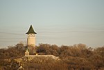
University Avenue is a street that runs through both Minneapolis and Saint Paul, Minnesota. It begins near the Minnesota State Capitol in Saint Paul and extends westward into neighboring Minneapolis, where it passes the University of Minnesota, and then turns north to pass through several suburbs before its main portion ends in Blaine, Minnesota, although there are stretches of road designated as University Avenue that are north of the Blaine terminus, the final stretch ending near Andree, Minnesota. For many years, the road carried U.S. Highway 12 and U.S. Highway 52 (at least for part of its length), and University Avenue is still a significant thoroughfare in the area. University Avenue originally ran along a line several blocks north of its current location, forming a route that once connected the Minneapolis campus of the University of Minnesota to Hamline University in Saint Paul (hence the name). When the construction of the Minnesota Transfer Railway yards blocked that route, the street was moved one-half mile to the south on the Saint Paul side, to what was then called Melrose Avenue. The old University Avenue route was renamed Minnehaha Avenue, which it remains to this day.Some important neighborhoods the road passes through include Frogtown (officially, the Thomas-Dale neighborhood) and the Midway region, both in Saint Paul. Hubbard Broadcasting and its flagship stations, KSTP-AM-FM-TV, are on University at the border of Minneapolis and Saint Paul. In fact, the sidewalk at the KSTP studios is right on the city/county line. This was one of the highest points in the area, an appropriate site for a radio transmitter. An antenna structure still stands there today, though it is used for microwave links rather than broadcasting (KSTP and most other Twin Cities stations use the Telefarm installation in Shoreview, Minnesota, or the nearby KMSP Tower). A water tower commonly known as the Witch's Hat stands just a few blocks away in Minneapolis's Prospect Park neighborhood. In 1890, the first interurban streetcar link between Minneapolis and Saint Paul used University Avenue and Washington Avenue in Minneapolis. History is now being repeated, as the METRO Green Line light rail connects the two downtowns as well as the University of Minnesota along a similar route. University Avenue carries Ramsey County Road 34 in Saint Paul, and Hennepin County Road 36 in Minneapolis to the junction with I-35W. West and north of Central Avenue, University Avenue carries Minnesota State Highway 47 to the junction with US 10, after which it carries Anoka County Road 51.

Malcolm Willey House

The Malcolm Willey House is located in Minneapolis, Minnesota, United States. It was designed by the American architect Frank Lloyd Wright, and built in 1934. Wright named the house "Gardenwall".Malcolm Willey was an administrator at the University of Minnesota. In June 1932, his wife Nancy Willey sent a letter to Wright asking if he would be able to provide them a "creation of art" for a budget of "about $8,000". The current design is the second design that Wright conceived for the Willeys, since the first design proved too costly for the family. The home ended up a modest 1,200 square feet (110 m2) at a cost of $10,000. The Willeys sold the home in 1963 to a family that later sold it to a Wright aficionado who only sporadically occupied the home; when the current owners purchased the home in 2002 it was in need of major restoration which is now complete. The Willey House is primarily built of red brick and cypress. Except for the red linoleum in the kitchen, the rooms on the main floor are floored with mortared brick pavers. A major design feature is the 30-60-90 triangle which shapes the terrace, the skylights, and two clerestory windows in the living room. The house is arranged so that the living room and dining room form a single space: the kitchen was separated from them by plate glass and a group of shelves. This gave a clear view from the kitchen to the living and dining area, allowing Mrs. Willey to watch the rest of the house while in the kitchen. This was an important step away from the historic precedent of compartmentalizing the functions of the house into separate rooms. The house can be considered a bridge between Wright's earlier Prairie School style houses, and his later Usonian style houses, since it incorporates certain elements from both styles.Located at 255 Bedford Street Southeast in the Minneapolis neighborhood of Prospect Park, the home remains private and is only partially visible from public roads. It sits adjacent to a freeway wall blocking it from the sight and sound of nearby Interstate 94; the home originally had a panoramic view of the Mississippi River gorge before the freeway's construction obstructed it in the 1960s. The house hosted the dedication ceremony for Interstate 94 on December 9, 1968.

Meeker Island Lock and Dam

The Meeker Island Lock and Dam (originally known as Lock and Dam No. 2) was the first lock and dam facility built on the Upper Mississippi River. Meeker Island was named after its owner Judge Bradley B. Meeker. Meeker County was named after him also. After a construction period lasting eight years, the site was only in operation for five years from 1907 to 1912 when the growing interest in hydroelectric power led to design and construction of today's Lock and Dam No. 1 a few miles downriver. It was realized that the new dam could take over the function provided by this first site and another small dam a short distance downriver. Lock and Dam No. 1 opened in 1917, and a hydroelectric plant was added there in the 1920s to power the Ford Motor Company's Twin Cities Assembly Plant. The Meeker Island dam was demolished, although some ruins of the lock remain. Tops of the old lock walls become visible during low water periods on the river. It is located in the Desnoyer Park neighborhood, north of the Lake Street-Marshall Bridge connecting Minneapolis and Saint Paul, Minnesota. The Meeker Island Lock and Dam ruins were added to the National Register of Historic Places in 2003. Each year, National Park Service historian Dr. John Anfinson and the Friends of the Mississippi River lead a tour of the lock and dam ruins. In 2005 a $380,000 restoration project began to create a public park near the dam. It was finished in 2007.The historic dam site and off-leash dog park are part of the Mississippi River Gorge Regional Park.

Prospect Park, Minneapolis

Prospect Park is a historic neighborhood within the University community of the U.S. city of Minneapolis, Minnesota. The area is bounded by the Mississippi River to the south, the City of Saint Paul, Minnesota to the east, the Burlington Northern railroad yard to the north, and the Stadium Village commercial district of the University of Minnesota to the west. The neighborhood is composed of several districts which include the East River Road area. The 1913 Prospect Park Water Tower is a landmark and neighborhood icon. An urban village once served by streetcar, Prospect Park is now a combination of multiple districts and uses. People live in single-family homes on Tower Hill, as well as apartment housing in the western districts. Estate homes of the early to mid 20th century line East River Road. The SouthEast Industrial Area (SEMI) in the north contains light manufacturing, rail yards and remnant grain silos. University Avenue houses a mix of retail and restaurant businesses from the Stadium Village area. The entire 138-acre (56 ha) core of the neighborhood was listed on the National Register of Historic Places in 2015 as the Prospect Park Residential Historic District for its significance in the theme of social history. It was nominated for its cohesive community spirit, developed—despite the neighborhood's hilly terrain and diverse housing stock—through such innovations as Minneapolis's first community association.