place

Cranham, Gloucestershire

Civil parishes in GloucestershireGloucestershire geography stubsStroud DistrictUse British English from March 2015Villages in Gloucestershire
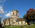
Cranham viewed from the east geograph.org.uk 671280

Cranham is a village in the English county of Gloucestershire. Forming part of the district of Stroud it is to be found a mile or so east of the A46 road between Stroud and Cheltenham. The Cotswold Way long-distance footpath also runs nearby. Composer Gustav Holst lived in Cranham for a while, and it was there, in the house now called 'Midwinter Cottage' that he wrote what is probably the best known tune for the Christmas carol In the Bleak Midwinter by Christina Rossetti. A Ham class minesweeper, HMS Cranham, was also named after the village. A Fairport Convention album, Gladys' Leap, is named after local postwoman Gladys Hillier, who would jump over a local stream to avoid a long journey. The Ordnance Survey have renamed that place in her honour.In 1948, Cranham Scout Centre was opened by the chief scout of the time. Over 2000 people attended the celebration of the opening ceremony. Since then it has developed from a small campsite into an activity centre with indoor accommodation. In 1949 George Orwell stayed at a sanatorium near the village, in his search for a relief if not a cure for the tuberculosis from which he was suffering and which would kill him six months later after his admission to University College Hospital. While in the sanatorium he sketched out in 4 pages of a notebook a short story to be called A Smoking Room Story, set in Burma. The story was never written.In 2010, pop star Lily Allen bought Old Overton House, just outside Cranham, for a reported £3 million. Old Overton House is grade II listed with the earliest part of the property dating back to the seventeenth century.

Excerpt from the Wikipedia article Cranham, Gloucestershire (License: CC BY-SA 3.0, Authors, Images).

Cranham, Gloucestershire
Main Street,

Geographical coordinates (GPS) Address Website Nearby Places
placeShow on map

Wikipedia: Cranham, GloucestershireContinue reading on Wikipedia

Geographical coordinates (GPS)

Latitude Longitude
N 51.8146 ° E -2.1522 °
placeShow on map

Address

Cranham Common

Main Street
GL4 8HP , Cranham
England, United Kingdom
mapOpen on Google Maps

Website
cranhampc.org.uk

linkVisit website

Cranham viewed from the east geograph.org.uk 671280
Share experience

Nearby Places

Gloucestershire
Gloucestershire

Gloucestershire ( (listen) (listen) abbreviated Glos) is a county in South West England. The county comprises part of the Cotswold Hills, part of the flat fertile valley of the River Severn and the entire Forest of Dean. The county town is the city of Gloucester and other principal towns and villages include Cheltenham, Cirencester, Kingswood, Bradley Stoke, Stroud, Thornbury, Yate, Tewkesbury, Bishop's Cleeve, Churchdown, Brockworth, Winchcombe, Dursley, Cam, Berkeley, Wotton-under-Edge, Tetbury, Moreton-in-Marsh, Fairford, Lechlade, Northleach, Stow-on-the-Wold, Chipping Campden, Bourton-on-the-Water, Stonehouse, Nailsworth, Minchinhampton, Painswick, Winterbourne, Frampton Cotterell, Coleford, Cinderford, Lydney and Rodborough and Cainscross that are within Stroud's urban area. Gloucestershire borders Herefordshire to the north-west, Worcestershire to the north, Warwickshire to the north-east, Oxfordshire to the east, Wiltshire to the south, Bristol and Somerset to the south-west, and the Welsh county of Monmouthshire to the west. The current Gloucestershire County Council area does not have the same geographical boundaries as the historic county. Some northern parts of the county, including Long Marston and Welford-on-Avon, were transferred to Warwickshire in 1931. Following the Local Government Act 1972, some southern parts of the county were transferred for administrative purposes to the new county of Avon, which ceased to exist on 1 April 1996. After 1996, the city of Bristol and South Gloucestershire became separate unitary authorities.