Nunawading, Victoria
Suburbs of MelbourneSuburbs of the City of ManninghamSuburbs of the City of WhitehorseUse Australian English from August 2019Vague or ambiguous time from June 2022

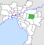
Nunawading is a suburb of Melbourne, Victoria, Australia, 18 km (11 miles) east of Melbourne's Central Business District, located within the Whitehorse local government area. Nunawading recorded a population of 12,413 at the 2021 census.Most of Nunawading is located in the City of Whitehorse, although the City of Manningham governs part of it. It is centred at the intersection of Whitehorse Road and Springvale Road, in Melbourne's eastern suburbs and is the site of the main office of the City of Whitehorse, as well as large retail (e.g. furniture, auto dealerships, hardware, and electrical) and wholesale businesses, along Whitehorse Road.
Excerpt from the Wikipedia article Nunawading, Victoria (License: CC BY-SA 3.0, Authors, Images).Nunawading, Victoria
O'Shannessy Street, Melbourne Nunawading
Geographical coordinates (GPS) Address Nearby Places Show on map
Geographical coordinates (GPS)
| Latitude | Longitude |
|---|---|
| N -37.817 ° | E 145.177 ° |
Address
O'Shannessy Street 55
3131 Melbourne, Nunawading
Victoria, Australia
Open on Google Maps


